
Engineer and Scientist: Learning Remote Sensing With STELLA
Ahadu Assegued joined Engineers Without Borders during his first week at Arizona State University. Three years later he is president of the chapter, and his path there ran through a plastic recycling project that shreds, washes, dries, and injection molds recycled pellets into new products. He became a team lead as a sophomore.
That is a useful thing to know before hearing about his research, because it explains what he noticed first about STELLA. Not the spectra. The access.
Assegued is entering his fourth year in aerospace engineering with a focus on astronautics at ASU’s Ira A. Fulton Schools of Engineering. Remote sensing had interested him for a while, mostly as something he wanted to pursue in graduate school. The route to it opened through the Fulton Undergraduate Research Initiative, known as FURI, an ASU program that places undergraduates into faculty research.
FURI connected him with Dr. Saurav Kumar, an assistant professor in ASU’s School of Sustainable Engineering and the Built Environment, whose group applies Earth observation to land use and water quality questions. Kumar had been talking with NASA about whether STELLA could work as both a teaching instrument and a research one. A previous student in the lab had already built a STELLA-1.1 from the open designs published by the Earth Sciences Division at NASA’s Goddard Space Flight Center.
The two of them wrote a small proposal. It was funded for two years.
The Question
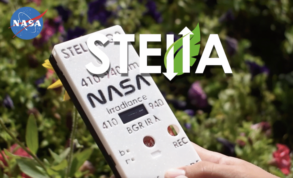
STELLA, which stands for Science and Technology Education for Land and Life Assessment, is a handheld multispectral spectrometer built from off-the-shelf microelectronics and a public parts list. It is low cost by design and open source by intent. The question Assegued took on was whether it can hold its own next to instruments that are neither.
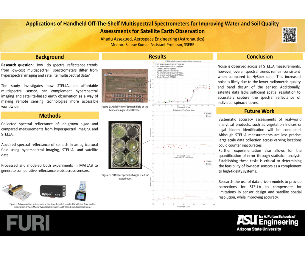
He compared it against a HySpex Mjolnir hyperspectral imager and PlanetScope Dove satellite data. His research question, as stated on his poster, was direct: how do spectral reflectance trends from a low-cost multispectral spectrometer differ from those produced by hyperspectral imaging and satellite multispectral data?
The fieldwork happened at the Maricopa Agricultural Center, alongside an ASU doctoral study on how cadmium affects spinach. That study had already established the plots he needed: spinach grown free of cadmium, spinach affected by cadmium with soil amendments to counter it, and spinach affected without amendments. Assegued focused on the control group and the unamended affected group, asking whether STELLA could detect a difference the hyperspectral imager could see.
In the lab he ran the same comparison with algae, measuring toxic and non-toxic species side by side.
The trends held. Noise appears across all STELLA measurements, a consequence of the sensor’s radiometric quality and band design, but the data points tracked the curves the hyperspectral imager produced. Quantifying exactly how closely is the next phase of the work.
What the Instrument Taught
The part of this project most relevant to anyone thinking about STELLA as a teaching tool is what happened when the measurements did not behave.
Working with a commercial imager, a student typically receives calibrated output. The corrections are applied somewhere in the software and the underlying decisions stay invisible. Kumar describes that as the difference STELLA makes.
“Often these things are masked, especially at a very entry level. If you have a working imager, all these things were taken care of by the software that you’re using, but you’re not really curating this thing yourself. So the learning is a lot more.”
– Dr. Saurav Kumar
Assegued had to curate it. He calibrated in the field against reflectance panels, worked out how often to recalibrate as sunlight shifted, and confronted integration time as something he controlled rather than something handled for him. He designed a 3D-printed housing to hold a quartz column wrapped in black fabric, standing in for a deep pond so that lab algae could be measured under conditions closer to a reservoir.
He also ran into a problem that no amount of care with the sensor could fix. Close to the plants, both STELLA and the hyperspectral imager returned clean measurements. The satellite did not. A PlanetScope pixel covers roughly nine square meters, and everything inside it gets averaged into a single value. Young spinach leaves do not fill nine square meters of anything.
His conclusion was that the target, not the instrument, had been the wrong choice. Next time he would work with something large enough to fill a pixel consistently, a forest or bushes rather than seedlings.
That is a scientific finding produced entirely by an engineering constraint. Kumar saw the same collision from the other direction, describing the comparison between an imaging spectrometer and a point reflectance measurement as an interesting engineering problem in its own right. Neither the science nor the engineering could be handled in isolation, which is the point.
Beyond the Lab
Assegued is deliberate about credit. Mahdis Khorram, a doctoral student at ASU, supported him throughout the data work. Mikko Dakota Roberts, a friend and fellow FURI participant, processed the aerial hyperspectral imagery into usable files. Harmonizing handheld, aerial, and satellite data in MATLAB took as many as five separate software packages and, by his own account, more help than he expected to need.
Asked what excites him most about STELLA, he did not talk about his own results. He talked about who else could be holding one.
“A lot of people tend to underestimate how important Earth observation is, and at the same time how difficult and inaccessible it is. We can have a whole team of scientists and researchers in US universities, or all sorts of countries. But being able to give this out to everyday citizens who can use this every day is, I think, the ideal we should strive for.”
– Ahadu Assegued
Asked what stands in the way of putting one in the hands of a farming cooperative, he did not name cost or expense.
“First is being able to make this universal and easily usable for everyone. Coming up with actual good protocols that make it easier for anyone to just pick up the device and use it and obtain quality data. The angle at which you put the device, how up or down it needs to be, the different settings.”
– Ahadu Assegued
The instrument is already simple to operate. Press a button and the data arrives. What is missing, in his view, is the field protocol that makes the resulting data trustworthy, and that is a documentation problem rather than a hardware one.
Kumar is interested in extending the same logic through education. He would like students to build their own units, calibrate them, work with them, and keep them after the semester ends. He has also raised the idea of lending kits through public libraries, so that community members could check one out and return with observations.
Why It Matters for Earth Observation
Kumar’s underlying interest is inland water. Water chemistry data is scarce, and satellites need ground measurements to validate what they observe. A single high-accuracy instrument produces excellent data in one place. A large number of low-cost instruments produce adequate data in many places, and for some questions that is the more valuable arrangement.
His framing shifts the accuracy question away from instrument specifications and toward outcomes.
“Even if STELLA is giving us imperfect spectral observations with a little bit higher uncertainty than we get from a lab-grade spectroradiometer, the question really was: even with this uncertainty, can we still get to the same management decision around, let’s say, nutrients in water?”
Assegued put the same idea in terms of what a network could do.
“If we’re able to deploy thousands of STELLAs in a specific region, collecting thousands of data points every single day, it allows us to calibrate satellite data, all the missing in-situ data sets that we need for satellites. And just the idea of making this cheap and accessible is the most interesting part.”
– Ahadu Assegued
Next semester he returns to the question with newer hardware, a statistical framework for quantifying error, and a considerably clearer understanding of what a satellite pixel can and cannot tell him about a leaf.
He is also, by then, a student who has built, calibrated, broken, and defended a scientific instrument. Whatever he measures next, that is the part that transfers.
Credits and programs
Research: Ahadu Assegued, Aerospace Engineering (Astronautics), Ira A. Fulton Schools of Engineering, Arizona State University. President, Engineers Without Borders at ASU.
Faculty mentor: Dr. Saurav Kumar, Assistant Professor, School of Sustainable Engineering and the Built Environment, Ira A. Fulton Schools of Engineering, Arizona State University.
Research support: Mattis Quorum, doctoral student, Arizona State University. Mikko Dakota Roberts, undergraduate researcher and FURI participant, Arizona State University. Field measurements were collected alongside an ASU doctoral study on the effects of cadmium on spinach.
Program support: Fulton Undergraduate Research Initiative (FURI), Arizona State University. Engineers Without Borders at ASU.
Field site: Maricopa Agricultural Center, Arizona.
Instrument: STELLA is designed and supported by the Earth Sciences Division, NASA Goddard Space Flight Center. Designs, parts lists, and build documentation are published openly.
Interview: Conducted by Michael Taylor, NASA Goddard Space Flight Center.
Instruments referenced: STELLA-1.1 multispectral sensor, HySpex Mjolnir hyperspectral imager, PlanetScope Dove satellite constellation.
Citations
Interview Transcript
Interviewer: Mike Taylor (NASA GSFC, STELLA Outreach Scientist) Guests: Clara Laughlin, Ingrid Roberson, Sarah Payne
00:00:04:15 – 00:00:08:13
say good morning. Ahadu. Thank you for taking the time to speak with me today.
00:00:08:13 – 00:00:11:11
Can you please tell us a bit about yourself and your schooling?
00:00:11:13 – 00:00:38:05
my name is Ahadu Assegued. I’m now entering my fourth year of engineering. I study aerospace engineering, and I’ve been involved with Engineers Without Borders since my first week at ASU. So three years now. I joined our project where we do plastic recycling. So we build machines that shred, wash, dry and then injection molded plastic, recycled plastic pallets into all
00:00:38:07 – 00:00:39:06
sorts of products.
00:00:39:06 – 00:00:54:10
And so I’ve been a team lead since my sophomore year. And then recently I became president of the club where I will take care of finding new projects, new partners and ways of hosting events, all sorts of things. Sponsorships. Yeah.
00:00:54:10 – 00:01:04:06
for you, professor, Saurav can you tell us a bit about yourself and how do and how you all connected through theSTELLA project and all that?
00:01:04:07 – 00:01:06:06
Sure. I am Saurav Kumar
00:01:06:08 – 00:01:14:06
an assistant professor in the School of Sustainable Engineering and Built Environment in the Ira A. Fulton College of Engineering at Arizona State University.
00:01:14:10 – 00:01:55:04
So my research group has been working on using that observation for various types of decision making and hyperspectral imaging. Ahadu connected with us through something called a FURI project. That’s an initiative that Arizona state university to get undergraduate students engaged in, in research. And I was really interested in trying to understand how satellite data and Earth observation in general can be used for, for, for, for land use, land cover change and other ideas around water quality.
00:01:55:05 – 00:02:25:04
So and, and really that is a time I had met you, Taylor, and we were Michael and we were trying to figure out that howSTELLA maybe a cool, nice, a nice educational and even research research tool. And as we know, some of the problems that we have around using Earth observation is lack of data, especially in inland waters and things like that.
00:02:25:04 – 00:02:53:05
So so I propose to Ahadu that maybe he can use it. So there was a student before who was making theSTELLA based on your designs? I think it was the early design 1.1. And so I Ahadu thought that was a good idea. And we wrote a small proposal and we got funded for two years. So that’s really how I got in touch with the hardware and, and how he has been doing
00:02:53:06 – 00:02:59:03
Well, I want to thank you both. And your email attached poster provided a fantastic overview of this
00:02:59:03 – 00:03:03:10
research. And to really kick things off, I’d like to hand the floor over to you Ahadu.
00:03:03:12 – 00:03:08:14
I’ve always found remote sensing an interesting subject. It was something and Earth
00:03:09:02 – 00:03:15:09
observation, and it was always something I wanted to get involved in for graduate school.
00:03:15:09 – 00:03:43:14
And I think that’s also why I chose aerospace engineering. And so from there, when I reached out to Doctor Kumar, I had the opportunity to work on STELLA and we worked on the STELLA-1.1 device with the STELLA-1.1 device, where we focused on collecting water and soil quality data usingSTELLA, and then comparing it, comparing it with a hyperspectral imager.
00:03:43:15 – 00:04:09:06
And the goal was to see if there’s overlap and similarities between what I get with STELLA and the Hyperspectral Imager, knowing that the image is a lot more accurate and is a lot more accurate. And so whereas STELLA has higher margins of error, and the goal of the project is to see how much of this error can be, how much of the STELLA data is accurate enough.
00:04:09:07 – 00:04:39:00
And so I’ve mostly been going on the field collecting spinach leaves and their reflectance data. And they did the same with algae in the lab and on the field. And I compared it with the what I got with the hyperspectral imager to see if there is any similarities between the two. Right now, we found trends that overlap, and the next goal is to see if we can actually quantify how much of how accurate still is compared to the imager.
00:04:39:01 – 00:04:43:07
And that’s my, I think, goal for the next semester.
00:04:43:08 – 00:05:08:02
That’s awesome. And you should know that just briefly before you got on, I was talking to Doctor Kamar, and I let him know about the 1.1 and that we had or I should say, I keep saying we. But one of our collaborators, Colorado State University, has found a bit of a flaw with the near infrared. With the integration time, I sent a link to the GitHub with their finding.
00:05:08:02 – 00:05:21:12
We would need to reprogram it in there and all that, but it might. It might affect some of your readings a bit, depending on what it is, but it’s only for the near infrared not for the, not for the visible.
00:05:21:13 – 00:05:24:15
to understand all the details which Ahadu is doing right now.
00:05:25:01 – 00:05:42:09
Like working how the integration time works and how those things work is, is, is really helping in leaps and bounds to to understand how like the spectral imagers eventually how they work.
00:05:42:10 – 00:06:04:08
So in the poster you noted the consistency and spectral trends between STELLA and the high fidelity HySpex imager despite the noise. Could you describe a specific example from your analysis, either with the algae or the spinach, where you saw this consistency and what that finding implies about the practical use for a low cost sensor?
00:06:04:09 – 00:06:16:10
Yeah. So in the case of the spinach, we went on the field. What we found was that we were able to see.
00:06:16:12 – 00:06:40:15
Because it’s 12 bands with STELLA we have. So it’s all been STELLA. We’re able to see how it progresses with the wavelengths and find a bit of overlap with the same groups that we’re targeting and with the different groups we were targeting. And so the hyperspectral imager, we would see the line and we would see the data points be similar to what we found with the imager.
00:06:41:00 – 00:06:46:07
Additionally, when we let me grab it right here.
00:06:46:08 – 00:06:58:10
When we focus on different we focus on different groups. So a first group had no amendments. A second one had we had a control group.
00:06:58:11 – 00:07:34:06
Okay. So restart this. Sorry. So when we studied this finish we had it was an ASU PhD student that was working on seeing how cadmium affects specialist. And so we had and if we’re able to pick up this behavior with the hyperspectral imager or STELLA. And so we had different different groups. Spinach leaves that had a certain amount of that had amendments to fight off the cadmium or had no cadmium at all, or had cadmium without any amendments.
00:07:34:06 – 00:08:10:00
So I focused on collecting data from our control group, which is the spinach, the cadmium free spinach, and then the amendment free cadmium affected spinach. And so when we’re collecting the data. We’re able to see that general trends where we’d have the lines with the hyperspectral imager, and then the data points overlapping with those specific lines. Similarly with the algae we did some we had a group, we worked in the lab where we collected reflectance data for toxic algae and then nontoxic algae.
00:08:10:00 – 00:08:38:14
And then with the algae we’re able to notice is that at around 650 nanometers, we were able to see a slight peak for the toxicology in reflectance, and then a drop for the nontoxic algae. And STELLA was a bit able to pick this up. And so now the next goal is to see how much accurate it is of any noise of just random look.
00:08:38:15 – 00:08:46:08
But I believe that the trends are there and what we start to see.
00:08:46:10 – 00:09:06:12
And you astutely identified the sensors, radiometric quality and band design as likely sources of the noise from an engineering standpoint, if you were tasked with briefing the STELLA-1.2 development team, what’s the single most important improvement you would advocate for, and what trade offs would you be willing to accept to achieve it?
00:09:07:09 – 00:09:40:10
Maybe say be able to have more bands, especially in the near infrared section. I think in the case of STELLA 1.1, we had around 12 bands, and when we’re comparing it to a hyperspectral imager, because we got a whole line, it can be a bit confusing because we have increments of the data points. So it goes from 550 if I’m not wrong to 610 and then 680.
00:09:40:11 – 00:09:53:06
And so we can’t really see what’s in between. But so yeah, maybe you get a bit more a few more minutes and then.
00:09:53:07 – 00:10:03:08
Correct me if I’m wrong, but I think it’s also the bandwidth being a bit too large. If we’re able to maybe find a sensor, it has a smaller.
00:10:03:09 – 00:10:09:11
Bandwidth. We’ll be able to get more precise data for the specific wavelengths. Yeah,
00:10:09:13 – 00:10:11:07
I guess the tradeoff would be cost.
00:10:11:07 – 00:10:35:09
can I can I ask you a question? Can I prompt you something here? Because we struggled a bunch with some simple stuff about where are we focusing on the leaf or are we? There’s a simple stuff. It’s not really very fancy. Like, can we like, how do we constrain things? It’s just engineering issue of how much pure pixel are we getting.
00:10:35:11 – 00:11:00:11
I mean is it there’s a pure pixel of what you’re getting on. So if I could see if you could put the LED or something, which kind of gives you the, you know, a laser thing, which gives you the, the area of cone where you’re getting it, it would be tremendously helpful, but I know it will kind of, I don’t know, maybe we turn it on and off because you don’t want it to be pick back up the whatever the laser light is on.
00:11:00:12 – 00:11:10:02
But I was thinking that that would be a cool thing to add some laser lights and see where the cone is or projected, so that you know that you’re actually getting what you’re looking at.
00:11:10:03 – 00:11:22:01
Yeah, because I think that was the biggest challenge we had with spinach leaves I was because they were just starting to grow. I had to get very close to the leaves themselves.
00:11:22:02 – 00:11:47:07
And so sometimes I don’t know if I’m getting soil data or if I’m actually getting the leaves, but yeah, there’s that. I know that there’s a 3D printed housing that you can fix on top of it, but what I noticed is it was way too high. So I wasn’t able to get a good idea of how much of the code is rejected, because I would get really close to the leaves.
00:11:47:09 – 00:12:07:07
So you worked on worked with data from a handheld sensor, an aerial imager, a satellite with significant data integration, integration challenge. What was the most difficult part of harmonizing those data sets in Matlab to ensure you were making valid apples to apples comparisons?
00:12:07:08 – 00:12:38:05
the hardest part was processing the different sources of the different data sets that come from different sources. So I would get data from Planet Labs, for example, and I would be required to use Python, which I’m not good at all at. And then I would have to take the data data from the hyperspectral imager, which I think it required us to use different softwares up to, I think five at one point.
00:12:38:06 – 00:12:41:13
And then.
00:12:41:14 – 00:12:55:13
Making sure that once I get all these data sets, that I have the right values, that I need to mess up anything STELLA was very easy to work with by far. I think STELLA is by far the easiest.
00:12:55:14 – 00:13:20:14
Data that I collected and processed, mostly because I would get everything on a CSV file. The rest of it was mostly getting all those huge data sets and converting them into a CSV file, and then adding them to Matlab, and it was pretty hard. Luckily, I had another PhD student, Mattis, who would help us a lot, and then my friend Mikko, who also worked on the project with me.
00:13:21:00 – 00:13:28:01
So that helped us get everything right done, done on time. If not, it would have been a bit of a challenge.
00:13:28:02 – 00:13:38:07
That’s fantastic. So you had two others, can you would you mind giving them? I know you give them sort of a shout out, but like their full names if you don’t mind.
00:13:38:08 – 00:13:42:04
Yeah. So the first one is a PhD student and is Mattis Quorum.
00:13:42:04 – 00:14:06:04
And then the second person was a good friend of mine. We worked, we did the FURI program together and its Mikko Dakota Roberts. Yeah. So we did it. He took care of mostly passing all the data from the Aerial Hyperspectral Imager into CSV files and then giving them out. Yeah.
00:14:06:06 – 00:14:27:07
So but it also brings up a critical point about data quality. And we were we I know we talked a little bit about this, but vital step in collecting reliable spectral data is calibration. Could you walk me through your infield calibration process for the STELLA sensor, for instance, I understand a folded weight sheet of paper was utilized as the white reference.
00:14:27:07 – 00:14:41:15
Unknown
How frequently did you perform that calibration to account for changing sunlight conditions, especially when you were when your goal was to compare that data to the HySpex Imager?
00:14:42:00 – 00:15:13:08
Unknown
So. So I had a I have a calibration plates for different places with different colors. And so I would take what’s most similar to the data I’m working with. So if I’m working with soil for example, would take a slightly darker color panel out of the floor, and usually I would start first by scanning the plates, the STELLA saving them and then collecting the data on the field.
00:15:13:09 – 00:15:53:03
Unknown
When I worked with the algae, I tried to replicate this outside instead of just the lab. So with that I would anytime there was clouds or would move to a new place, I would start collecting calibration data again in the lab. I would say I because they’re still changing, like changing lighting conditions, that they’re there. I would just start once, collect all the calibration data I need, and so take data from the four panels, save them, and then when processing the data I would see whichever the four panels is the best and then keep it.
00:15:53:03 – 00:15:56:09
Unknown
So that’s what I did for the algae in the lab. But yeah
00:15:56:10 – 00:16:05:13
Unknown
fantastic. And do you remember what material your your panels were made out of. Was it spectral on or spectral flecked or
00:16:05:14 – 00:16:15:11
Unknown
do you have to know, professor I don’t know. It’s not spectral of. It’s a cheaper material. But we did have spectral on two I don’t.
00:16:15:12 – 00:16:32:01
Unknown
Sure. What material is that? It’s what. It’s one of the panels we had from MAPIR. There was they have this images that reflect multispectral images and they use those for that. So that’s what we were using.
00:16:32:02 – 00:16:37:11
Unknown
if you do find out what the specific material is, I’d love to know. Yeah, yeah, I’ll look into it.
00:16:37:11 – 00:16:40:15
Unknown
What are they using?
00:16:41:00 – 00:16:49:14
Unknown
I think I found it I mean, that’s fine. So this is the targets that we are using though.
00:16:50:00 – 00:16:56:10
Unknown
So in your future work section, how do you propose using data driven models to correct forSTELLA’s limitations?
00:16:56:12 – 00:17:04:12
Unknown
Could you elaborate on that? And what kind of model are you envisioning and what would you need to train it effectively?
00:17:04:14 – 00:17:40:03
Unknown
that’s something that I briefly discussed with the professor and Mattis, but it’s really my expertise or much comfortable. But I know that a lot of the research has get this done often involves machine learning. So I was suggesting that something that’s worth exploring, but I think the best the way I envision it is if we’re able to have some sort of model that’s able to.
00:17:40:05 – 00:17:55:01
Unknown
Recognize how accurate data is based on what you feed it. So let’s say you train it enough times on actual field data that we gathered with STELLA and hyperspectral Imager. And then.
00:17:55:02 – 00:18:16:10
Unknown
Comparing. And then once you have strained model propose take your data any STELLA data and then upload it to the system and you get some sort of something in return. I guess some sort of like confidence range, but it’s not really something I’m fully confident and aware of. So yeah, it was just something that I thought would be nice to discuss.
00:18:16:10 – 00:18:17:03
Unknown
But yeah.
00:18:17:04 – 00:18:32:09
Unknown
what about you, professor? So I think that the idea is the end decision that we want to make is, is about water quality. Even if STELLA is giving us.
00:18:32:11 – 00:18:58:15
Unknown
Imperfect spectral observations or with the high a little bit higher uncertainty than we get from a lab grade spectrometer aspect to radiometer. The question really was that even with this uncertainty, can we still get to the same end management decision around, let’s say, nutrients in water. So that’s where we are trying to see if we can feed that model.
00:18:58:15 – 00:19:34:06
Unknown
We can develop these data driven models with enough samples where we can we collect enough observation data for spectral observations and known target known values to say water chemistry analysis. And then can we still get to a reasonable endpoint in terms of what the value should be, even if the set of data is a little bit not accurate or it’s it’s it has a little bit higher uncertainty around it.
00:19:34:07 – 00:19:52:06
Unknown
And that’s really what we are trying to get to. And and see if what is the conference and confidence interval. How does it change if we use hyperspectral imager which is well calibrated versus STELLA multispectral datasets.
00:19:52:08 – 00:20:10:03
Unknown
from an academic and pedagogical perspective, how do you see open source low cost instruments like STELLA changing the way engineering and remote sensing students approach remote sensing and field data collection compared to traditional high cost lab equipment?
00:20:10:05 – 00:20:31:09
Unknown
I think this this is this is tremendous and really a neat way for students to go from all the way from learning about how these microcontrollers exist and how can you how can you combine them with, with, with the off the shelf microelectronics and build this cool little device?
00:20:31:09 – 00:20:53:10
Unknown
And then you also learn about all the all the other things that go into in integration times and and saturation. Often these things are masked, especially at a very entry level. If you have a working image, which is maybe it is working imager. All these things were taken care of by the software that you’re using, but you’re not really curating this thing yourself.
00:20:53:10 – 00:21:21:09
Unknown
So you will. So the learning is, is, is a lot more. And then and not to say not to talk about like it’s accessible. It’s all the electronics. I think the prices are going up now. But it was around $215, which is which is really cheap as compared to a $5,000 multispectral imager that you will get. Even even point samplers are not very not so much available and inexpensive.
00:21:21:10 – 00:21:43:11
Unknown
So I think this is tremendous. And I wish we could create like 50 of these and just send it out to the whole whole crew. Maybe they should create it themselves and take it with them after the semester finishes it. Go build one build sensor, calibrate it, go work with it and then take it with you. Do whatever you want.
00:21:43:12 – 00:22:15:01
Unknown
I remember thinking, talking about this idea with with few folks who work on citizen science idea things, and they were suggesting like creating a kit for libraries where they can we can learn it, they can learn it out, and then people can just go and do whatever they want with it and then come back with some observations. So, so there’s lots of ways, even beyond engineering or graduate education, where you can kind of use it.
00:22:15:01 – 00:22:31:12
Unknown
It’s a I cannot stand off about it. It’s a great device. It’s a really good introduction to many people, to microelectronics programing, even I think using a circuit Python. Is that what you’re using? And and all those things. It’s really cool way to get into those things.
00:22:31:14 – 00:22:33:11
Unknown
Ahadu what do you think?
00:22:33:14 – 00:23:21:11
Unknown
Yeah. So I think just the idea of involving citizen science is perhaps the most interesting thing to have about STELLA so far. And I say this because I have the feeling that a lot of people tend to underestimate how important Earth observation is, and also how. How and at the same time difficult and inaccessible it is. And so being able to work on making this technology more accessible, especially through citizen science, because at the end of the day, we can have a whole team of scientists, researchers in the US, in the US, universities, or all sorts of countries.
00:23:21:14 – 00:23:48:13
Unknown
But being able to give this out to everyday citizen for citizens that can use this every day is ideally is, I think, the goal we should the ideal we should strive for. Because I can definitely imagine a farmer would definitely appreciate having a sensor for just the steepest $200 and know of this. Plants and stock is going to survive some sort of monsoon, or is if it’s affected or not.
00:23:48:13 – 00:23:58:13
Unknown
And so being able to make this technology more accessible is, I think, very important. And the most interesting part about STELLA.
00:23:58:15 – 00:24:19:07
Unknown
Oh, cool. And in a vein. So the next question is basically connecting this to your work with Engineers Without Borders, which often discusses and focuses on sustainable community level solutions. What do you see as the biggest real world hurdle to putting a tool like this into the hands of a local farming cooperative?
00:24:19:08 – 00:24:24:12
Unknown
Is that the cost, the expertise needed to interpret the data or something else entirely?
00:24:24:13 – 00:24:50:09
Unknown
I’d say first is being able to make this universal and easily usable for everyone. And so coming up with actual good protocols, that makes it easier for anyone to just pick up the device and use it and obtain quality data. So the angle of which you put the device, how up or down needs to be the different settings.
00:24:50:09 – 00:25:12:07
Unknown
And so being able to transmit this all this knowledge and make it accessible first, because at the end of day sellers just you just press the button and you get the data quickly. But I think first of all, the first challenge is drafting and having an actual proposal and protocol for when you go out and collect field data.
00:25:12:07 – 00:25:18:07
Unknown
And so if we’re able to get quality field data out of this.
00:25:18:09 – 00:25:22:05
Unknown
how do this project require you to wear two hats?
00:25:22:06 – 00:25:40:14
Unknown
The scientists interpreting spectral signatures and the engineer understanding sensor limitations. Can you share a moment where a scientific goal forced you to be creative with the engineering, or an engineering constraint, made you reevaluate your scientific approach?
00:25:40:15 – 00:25:43:15
Unknown
I think.
00:25:44:00 – 00:26:09:11
Unknown
The main thing I noticed was working with satellite data and trying to incorporate that part and noticing that. So I would get really good data with hyperspectral imager and STELLA, because I was able to get very close to the leaves with the hyperspectral imager, zoom in and get any sort of reflectance plot that I wanted. And then I tried to do this with satellite data from Planet Labs.
00:26:09:15 – 00:26:34:01
Unknown
I would get a square of about, I think, nine meters squared and surface. So well, it just ends up doing is just it mixes up all the reflectance data, averages it out and gives it out for that box. And so I wasn’t able to really and I was able to notice how inconsistent satellite data was from the HySpex data.
00:26:34:01 – 00:26:54:12
Unknown
And unfortunately, it was too late for the semester for me to present and rework on integrating satellite data. And so what I realized is, if I want to get actual quality data for plants, I would need to have large cover like big.
00:26:54:12 – 00:27:26:05
Unknown
So yeah, the biggest challenge I faced with integrating satellite data with STELLA was how different the surfaces I was getting. How different are let me restart. Sorry. So when integrating satellite data with STELLA, I noticed that I would get a square of nine meters squared for all my wavelengths, for my reflections plot, and so average would average all of that surface into one big plot.
00:27:26:05 – 00:27:50:14
Unknown
And so when I was with STELLA and a hyperspectral imager, I was able to get very precise data points because I would either be very close to the leaves or was able to zoom in and get the right pixels I needed. And so the next step, what I would have to improve and work on would be finding a larger cover land that’s covered with the same consistent material.
00:27:50:14 – 00:28:13:06
Unknown
So if I’m working on leaves or threes, find something where I would have at least nine meters squared of the same consistent material all across that pixel, and then use it with STELLA or the hyper spectral imager. And so that would be one way of fixing my previous approach. And so maybe working with spinach leaves wasn’t the best decision.
00:28:13:06 – 00:28:20:12
Unknown
And maybe moving to something bigger like a forest might or bushes might be better.
00:28:20:13 – 00:28:37:03
Unknown
well and professor, I guess I would, I would also ask you if you had noticed any different, you know, basically where, you know, science helped, you know, with something and or that the engineering didn’t or the engineering and vice versa, basically the same question that I had.
00:28:37:06 – 00:28:44:13
Unknown
But if you noticed any of these types of things with these trade offs with the STELLAs.
00:28:44:14 – 00:29:13:01
Unknown
I think I’m still a mind, but I think the spectral resolution that Ahadu was getting to the point versus imager like. So I think the the idea was that is a imaging spectrometer, the hyperspectral image that you’re looking at. And now you all of a sudden committing trying to understand this, to compare this to a point reflectance. So the clash it’s an interesting.
00:29:13:03 – 00:29:36:03
Unknown
Engineering problem to how do you compare the data sets. And so because we were working with pixels mostly big enough so that again, that same thing that I was talking about, there were times that you were using in mixed pixels, it would be fine enough with the hyperspectral imager to do it because they are really close enough. You can get centimeter resolution or even ten millimeter resolution.
00:29:36:03 – 00:29:45:12
Unknown
But even with STELLA very close up, it’s not getting the.
00:29:45:13 – 00:30:07:15
Unknown
Pixels. So that was kind of an engineering problem with I think eventually we solved it by using bigger but basically changing our target. So but I now that you have talked about it, it might be interesting to look at if what if we place the engineering solution might be to actually just place dark, which is, which has almost no reflectance.
00:30:07:15 – 00:30:20:05
Unknown
So and the now you have created some sort of a and you know how much area you are going. So you can kind of scale it in and figure out what’s going
00:30:20:07 – 00:30:38:10
Unknown
So you’ve established a solid baseline for how STELLA performs in a traditional agricultural field. So let’s imagine you need to deploy a similar sensor network in a much more controlled environment, say like a greenhouse or a vertical farm where every input is meticulously managed.
00:30:38:10 – 00:30:48:07
Unknown
How would your strategy for validating and using the sensor data change in that kind of closed loop system?
00:30:48:08 – 00:30:52:13
Unknown
So,
00:30:52:14 – 00:31:22:10
Unknown
I think maybe we’re able to get. So if the goal is to compare with hyperspectral nature, I would say maybe just scale it down and find another device. But one thing I have to say, see if we get consistency between different STELLA data sets. So if we’re able to use different STELLA sensors, so have maybe repeat the same experience for 3 or 4 times and see if we actually get quality data.
00:31:22:11 – 00:31:49:02
And then perhaps simulate the experiment in a setting that’s more comfortable to using an aerial image. But and yeah, I would say maybe using different STELLA devices to see if we’re able to get consistent data between the two, between the different devices first. Yeah.
00:31:49:03 – 00:31:59:14
Fantastic. And your thoughts, professor? Yes. So I think it’s kind of interesting if you have a very controlled environment, I suppose your objective changes.
00:31:59:14 – 00:32:22:08
Right now you’re looking for anomalies as, as Ahadu was talking about. So it may be interesting. I’m thinking of a tomato farm with, with irrigated with, with everything control, lighting control and everything else. And now all of a sudden, all the STELLAs are looking at your plans and you have big not because but a lot of plan that you can manually go through everything.
00:32:22:08 – 00:32:41:14
You’re looking for calcium deficiency in one of those. So if you find few and only like normal reflectance and this could be automated, every plant could have its own sensor looking at it. And then and then we could look at just anomalies and trying to figure it out where.
00:32:41:15 – 00:33:02:07
And then think of that as a, as a, as a like I guess, what do you call that this automation for agriculture folks. But yeah, it would be pretty cool but don’t know much. Doesn’t have any question, but just haven’t thought about it. Let’s put it that way.
00:33:02:08 – 00:33:19:05
looking at what has achieved with this baseline comparison, how does this specific project inform your lab’s future red map for future Earth observation technologies or upcoming experiential learning missions? I know you already talked a little bit about it, but you can go in further in depth, possibly.
00:33:19:09 – 00:33:50:00
I, I think my lab and I’m very interested in trying to use Earth observation for, particularly for inland water resources and trying to understand small parts in the chemistry where I feel that one, the limiting problems there is a lack of data sets on on water chemistry and also data that can help us validate what satellites are observing.
00:33:50:02 – 00:34:16:08
So it seems like the what STELLA can do. And I’ll make a case for I guess it’s a nice case where you can use existing citizen and and community science projects and give them a STELLA observation. And then you can all of a sudden you have a lot of data for lots of different ponds around the around the United States or around the world tied to the overpass.
00:34:16:12 – 00:34:17:14
And then all of
00:34:17:14 – 00:34:40:06
a sudden you have a way to, to, to to validate those things. And that’s really to me, it’s a it’s a really powerful tool. Of course, we need to validate that this actually works very well and anybody can use it, which I think is a reasonable expectation that. Yeah. So that’s where I think we are going to try it.
00:34:40:06 – 00:34:46:13
And and hopefully we’ll figure out some way to get this working.
00:34:46:14 – 00:35:04:07
Fantastic. Yeah. We like to call it opportunity resolution as well. So every people have the opportunity to gather the data as much as possible. Yeah. Okay. And then this is the final question. And again I want to thank you all very much for your time. Yeah. Thanks for doing this.
00:35:04:07 – 00:35:11:11
Unknown
But finally, how do thinking about the big picture of making Earth observation more accessible?
00:35:12:02 – 00:35:27:11
What in situ application for a sensor like STELLA excites you the most? Personally, what’s a new scientific question you’d be excited to answer if you could deploy, say, thousands of these sensors and we touched a little bit on it. But,
00:35:27:12 – 00:36:00:11
so I think this brings it back to what we when we discussed about citizen science earlier, if, let’s say we’re able to deploy thousands of dollars in a specific region, I think it would be really interesting to see if we’re able to mimic what we get from satellites using using STELLA, and if that works, by having thousands of dollars, where we collect thousands of data points every single day, it allows us to, first
00:36:00:11 – 00:36:33:06
of all, props calibrate satellite data, all the missing data sets that we need of in-situ data for satellites, and just the idea of making this cheap and accessible is, yeah, the most interesting part. So yeah, I would definitely say just deploying it out and then see if we’re able to get similar data as what we get from a satellite or a hyperspectral imager, for example.
00:36:33:07 – 00:36:34:02
Yeah.
00:36:34:04 – 00:37:11:12
Okay. And same question for you, doctor. I think I’ll just hop back to the last as and really, I feel like if you have thousands of STELLA and if you can fill that water quality gap, and somehow we figure out that you can measure water quality and small farms across United States using STELLA. And maybe it’s like I remember seeing a wet one where you have a keyword you had some and pointed out to them and measure the reflectance, and that gives you the nitrate and the phosphorus, and then do it around the time that is light is passing.
00:37:11:14 – 00:37:31:14
Unknown
Now all of a sudden you have a very rich data set where you can now create the link your satellite observations to on ground measurements. Maybe it’s a point measurement and we can figure it out. Maybe they make ten measurements and combine them together. So so that creates a rich library that can be used eventually to monitor long term.