
Figure 1. An RGB rendition of the Landsat Thematic Mapper data set used in the example. Spectral band 5 is displayed as red, spectral band 4 is displayed as green and spectral band 2 is displayed as blue. Washington, DC is in the lower left of the image and Baltimore, MD is in the upper right. The mid-central portion of the Chesapeake Bay is seen on the right side of the image.

Figure 2. The optional graphical user interface for inputting parameters to and starting the Region Labeling Tool for selecting a unique segmentation from a set of hierarchical segmentations.

Figure 3. The main graphical user interface panel for the Region Labeling Tool.

Figure 4. The RGB Image Display panel for the Region Labeling Tool. The image is panned so that it is centered to the southeast of Baltimore, MD over the west central part of the Chesapeake Bay.

Figure 5. The Current Class Labeling Display for the example Landsat TM data set. The region highlighted in purple is the region containing a pixel in the middle of the Chesapeake Bay from the finest segmentation level (level 0) from the segmentation hierarchy.

Figure 6. The main graphical user interface panel for the Region Labeling Tool with hierarchical segmentation level 1 selected from the segmentation hierarchy for a pixel in the middle of the Chesapeake Bay. The number of pixels in the selected region at level 14 (974,337) is only marginally higher than the number of pixels in the selected region at level 1 (972,833). This suggests using segmentation level 14 may be appropriate.

Figure 7. The Label Region panel for the Region Labeling Tool in its initial configuration.

Figure 8. The Label Region panel for the Region Labeling Tool after changing the "Change Colors When Labeling" response to "NO" and labeling the bodies of water (including the Chesapeake Bay) region with the color blue and the alphanumeric label "Water."

Figure 9. The Current Class Labeling Display after labeling the bodies of water (including the Chesapeake Bay) region with the color blue.
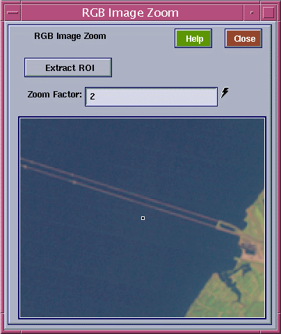
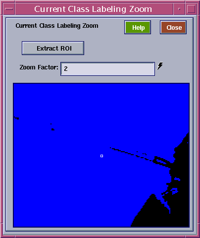
Figure 10. (a) RGB Image Zoom panel with zoom factor equal to 2 and image panned to the area of the Chesapeake Bay Bridge (U. S. Highway 50). (b) Current Class Labeling Zoom panel with zoom factor equal to 2 and image panned to the area of the Chesapeake Bay Bridge (U. S. Highway 50). Note that most of the bridge is merged together with the Chesapeake Bay waters at this point.

Figure 11. Current Class Labeling Zoom panel with zoom factor equal to 2 and image panned to the area of the Chesapeake Bay Bridge (U. S. Highway 50). The region highlighted in purple resulted from selecting a pixel in the "Water" region in Figure 10b. which appears to be on the Chesapeake Bay Bridge in Figure 10a. Along with the Chesapeake Bay Bridge, a small number of additional "water edge" pixels are highlighted.

Figure 12. The Current Class Labeling Display after labeling the "Industrial/Dense Urban/Water Edge" region with an orange color. The blue colored regions are bodies of water. Note the Sparrow Point industrial area in the center right of the image, the Key Memorial Bridge just to the left of the Sparrow Point industrial area, and the Baltimore Harbor and Downtown area to the upper left.

Figure 13. The current class labeling for the entire scene with "Water" regions as blue, "Wooded" regions as green, "Industrial/Dense Urban/ Water Edge" regions as orange and "Bridges/Water Edge" regions as brown.

Figure 14. The optional graphical user interface for inputting parameters to and starting the Region Labeling Tool. In this case the interface is set up for restarting the tool from the "Input Class Label Map" /data10/.../tm153393.label_in and "Input ASCII Class Label Names" /data10/.../tm153393.ascii_in.

Figure 15. The current class labeling for the entire scene after labeling the "Urban" regions with the color yellow. In addition, the "Water" regions are colored blue, "Wooded" regions are colored green, "Industrial/Dense Urban/Water Edge" regions are colored orange and "Bridges/Water Edge" regions are colored brown.

Figure 16. The current class labeling for the entire scene after labeling the "Roads/Moderate Urban" regions with a light yellow color. In addition, the "Urban" regions are colored yellow, the "Water" regions are colored blue, "Wooded" regions are colored green, "Industrial/Dense Urban/Water Edge" regions are colored orange and "Bridges/Water Edge" regions are colored brown.

Figure 17. The current class labeling for the entire scene after labeling the "Grasslands/Parks" regions with a very light green color. In addition, the "Roads/Moderate Urban" areas are colored light yellow, the "Urban" regions are colored yellow, the "Water" regions are colored blue, "Wooded" regions are colored green, "Industrial/Dense Urban/Water Edge" regions are colored orange and "Bridges/Water Edge" regions are colored brown.

Figure 18. The Label Region panel for the Region Labeling Tool after a nearly complete labeling of the example Landsat TM scene. Note the color to alphanumeric phrase correspondence for the twelve defined land cover classes.

Figure 19. The current class labeling for the entire scene after the labeling has been nearly completed. The class to color correspondence is as given in Figure 18.

Figure 20. A blown up 768x768 pixel section of the RGB rendition of the example Landsat TM data set in the area of the thin hazy clouds. These clouds can be seen in the center left portion of this image as well as in the upper left and upper right portions.

Figure 21. A blown up 768x768 pixel section of the current class labeling of the example Landsat TM data set in the area of the thin hazy clouds. The black areas are unlabeled due to the influence of the thin hazy clouds, and some labelings in the area of the thin hazy clouds are incorrect. The class to color correspondence is as given in Figure 18.

Figure 22. A blown up 768x768 pixel section of the current class labeling of the example Landsat TM data set in the area of the thin hazy clouds. The highlighted purple areas are wooded areas under the thin hazy clouds. The class to color correspondence is as given in Figure 18.

Figure 23. A blown up 768x768 pixel section of the current class labeling of the example Landsat TM data set in the area of the thin hazy clouds. The highlighted purple areas are grassy or park areas under the thin hazy clouds. The class to color correspondence is as given in Figure 18.

Figure 24. A blown up 768x768 pixel section of the complete current class labeling of the example Landsat TM data set in the area of the thin hazy clouds. The class to color correspondence is as given in Figure 18, with the addition of the "Unclassifiable because of haze" class that is colored dark red (the last color labeled "(undefined)" in the right column of the color to class correspondence table in Figure 18).
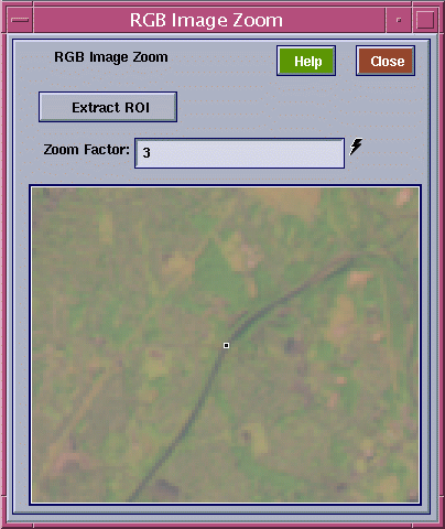
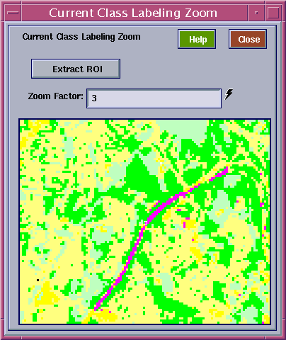
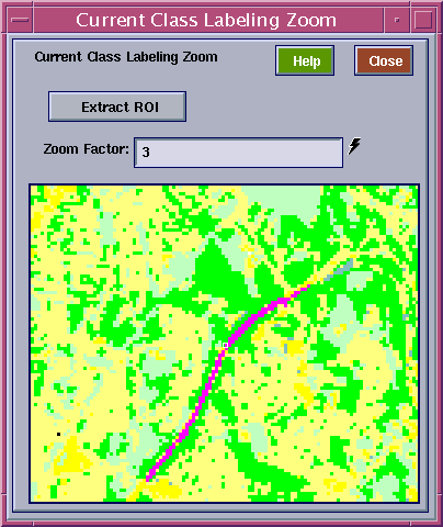
Figure 25. (a) RGB Image Zoom panel with zoom factor equal to 3 and image panned to the area over Interstate 95 in the northeast part of Baltimore, MD in-between the junctions with Interstate 695 and Interstate 895. (b) Current Class Labeling Zoom panel with zoom factor equal to 3 and image panned to the area over Interstate 95 in the northeast part of Baltimore, MD in-between the junctions with Interstate 695 and Interstate 895. The region highlighted in purple was obtained by selecting a pixel on Interstate 95 that was previously labeled as "Water Edge/Marsh/Shadow" and using the level 0 segmentation from the segmentation hierarchy. (c) Current Class Labeling Zoom panel with zoom factor equal to 3 and image panned to the area over Interstate 95 in the northeast part of Baltimore, MD in-between the junctions with Interstate 695 and Interstate 895. The region highlighted in purple is the result of selecting "Label Spatially Disjoint Regions Separately" instead of the default "Label Spectrally Similar Regions Together" on the main graphical user interface of the Region Label Tool (see Figure 6), after starting from the highlighting in Figure 25b. This region is the result of connected component labeling starting with the selected pixel for the selected level (level 0) in the segmentation hierarchy.