Early Career Scientist Spotlight
Dr. Nishan Kumar Biswas (he/him/his)
Hydrologist
Hydrological Sciences Laboratory (617)
Did you always know that you wanted to be a hydrologist?
Nope. I grew up in a very small farmer family situated in a remote village of Bangladesh without having electricity access until the end of 2014 at my home (just to provide context so that you can imagine how remote that is). Because of this, I was not very ambitious in my academic career. My first choice was to become a farmer to support my family. When I was doing well in my elementary school classes, I changed my mind and planned become a police officer. In 8th grade, one of my teachers encouraged me to take arts or business studies instead of science as my major and explicitly mentioned that I was not very good at science. However, I somehow managed to convince my parents to allow me to study science, as I always loved math and science.
I did very well during my Secondary and Higher Secondary School programs and I started preparing for my undergraduate admission into college. At that time, I started seeing computers with my own eyes and was thrilled to see how they can change our ways of thinking, so I planned to study computer science in my undergrad. I was not eligible to enroll in computer science; instead, I was selected for Water Resources as my major. During my senior year of studying water resources, I was able to understand the application of computer models and programming in the hydrology and water resources fields, and I finally started enjoying working on solving different problems using both my academic training in hydrology and my passion for computer science. Fast forward 14 years, I feel like I enjoy a lot of what I am doing right now.
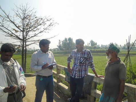
Credit: Fahim Ryan Raihan
What is your research focus?
My research is mainly focused on using satellite remote sensing data to improve our ability to monitor and predict water disasters, specifically in understudied regions of the world. After my bachelor’s degree in water resources, I started working with a group of professionals to implement a country-wide operational flood forecasting of Bangladesh. It is worth mentioning that the country has three large transboundary rivers. We realized that there are some unavoidable limitations associated with ground measurements (inconsistent data records, affordability, transboundary issues, lag between data acquisition and transfer to the center, inaccessible areas) — all aspects that need to be addressed to produce an accurate forecast. At that moment, I realized the importance and application potential of remote sensing data provided by NASA and other space agencies which can address most of the above-mentioned issues in data-scarce regions. However, I found that stakeholder organizations in developing nations are often unconvinced to depend on remote sensing platforms for operational purposes because of several reasons: 1) Uncertainty of remote sensing data as it is measured “indirectly”, 2) lack of understanding of different satellite platforms and multi-spectral complex data, and 3) unavailable computational resources along with internet bandwidth limitations. During the last 7 years, I have been focusing on the above-mentioned three key factors.
As a solution to the first key issue, I found that if we use information from multi-source satellites instead of depending on a single one, it can minimize the uncertainty associated with a single satellite measurement. As an example, in the case of dynamic rivers, altimeter satellite-derived river elevations are not very accurate, especially during the dry season. These estimations can be improved by using river extent information derived from additional satellites such as Landsat and Synthetic Aperture Radar (SAR). As another example, I showed that near-real-time monitoring of reservoir operation such as water surface extent area, storage variability, inflow, and outflow can be observed accurately at the global scale based on only satellite observations.
To address the second key issue, while performing the studies mentioned above, I always consider converting my research findings into actionable information so that it can be easily used by the stakeholder agencies, as well as policy makers, without needing a deep understanding of hydrology and remote sensing. I also work with several South-Asian agencies to improve their capacity so that they have a better understanding of the vast amount of satellite data and platforms and their potential.
To address the third key issue, I have been focusing on how we can leverage advanced IT infrastructure (i.e., cloud computing, web-based apps and user interfaces) to reduce the computational resource limitations of developing nations. Overall, I have been having multiple pieces of evidence that satellite observations provided by NASA and other space agencies have great benefits that can be used wisely and timely for better water and disaster management.
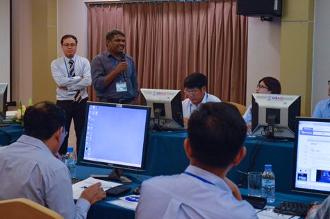
Credit: Nguyễn Hoàng Hiệp
What is one research project that you are particularly excited about, and why?
I am excited about a number of my research projects, but if I were to choose just one of them, I would say the near-real-time reservoir-monitoring framework I developed during my doctoral study was some of the best work I have ever done. The framework was built to leverage multiple satellite observations along with cloud computing to address the limitations usually faced by the water managers and stakeholders in developing nations, especially in transboundary river setting. In that study, I was able to demonstrate that a huge part of the world can benefit tremendously from this framework, because it is completely open source, scalable, and customizable. Everything is publicly available.
This framework that I developed takes the latest available satellite imagery to extract reservoir surface water extent area, and then calculates storage change from the surface water extent area using Shuttle Radar Topography Mission (SRTM) data-based area-elevation relationship. The framework also uses a hydrological model and the latest available hydrological observations to generate reservoir inflow. Using inflow and storage change, it calculates the outflow using the concept of reservoir mass balance. The developed framework is completely unbiased to any nations because all the datasets are satellite-derived, bringing transparency to reservoir operation. It can help resolve concerns between riparian nations and can help largely in basin-wide integrated water management. Many regional agencies have been showing a great deal of interest in it since the development, and the concepts are being prototyped into regional scale to attain better accuracy in measurements.

Credit: Nishan Kumar Biswas
What are your future research interests and goals?
Based on a considerable number of studies, it has been clearly shown that the frequency and intensity of natural disasters are increasing in recent times due to several reasons. A vast majority of the world is not well-prepared for these events, and the accurate monitoring and prediction of these events are necessary for short-term decision making and long-term policy analysis. It is clear that there is great potential for satellite remote sensing data platforms and models in this field with their higher frequency of observation and hyperspectral resolution. The challenges that we need to study are how we can leverage more accurate models, the application of artificial intelligence, and cloud computing to address the computational limitations to use petabyte-scale information produced by the satellite platforms. Commercial satellites are evolving and much more hyperspectral data are coming in the near future which will bring boundless possibilities.
In the future, I will be focusing on how research findings can be transformed into actionable information for stakeholder organizations and how the limitations associated with computational resources can be minimized using cloud computing facilities (such as Google Earth Engine, Microsoft Planetary Computer), so we can use this vast amount of data for the greater good of the humanity.
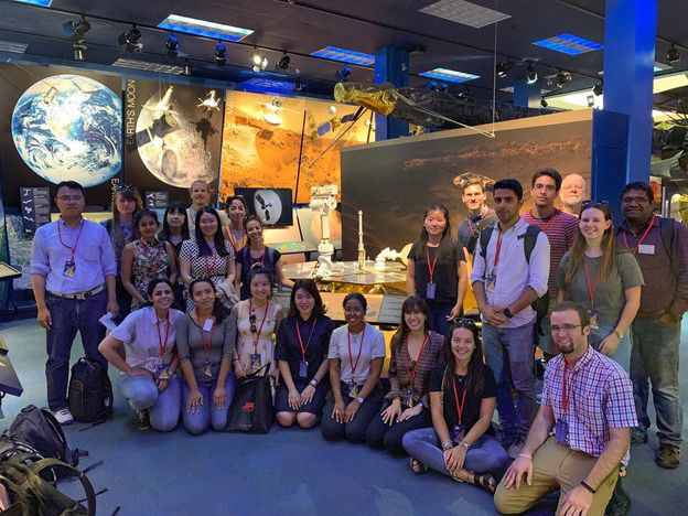
Credit: Areidy Aracely Beltran Pena
What is one space mission that you are particularly excited about, and why?
I am particularly excited about the Global Precipitation Measurement (GPM) mission. It is a standard example on how international agencies can work together for satellite constellations that can provide next-generation global observations. The mission has been providing information about precipitation in the near-real-time, which has been helping scientists and researchers to advance our understanding of Earth's water and energy cycles. The accurate and timely information of precipitation from this satellite has been helpful in quantifying extreme events, which leads to greater benefits of the society.
Since 2015, I have been using the GPM satellite-provided precipitation measurements in relation to a number of impactful studies. I have used the near-real-time precipitation products for hydrological modelling, monsoon flood forecasting, flash flood forecasting, smart irrigation services, crop monitoring, reservoir monitoring, and landslide hazard monitoring and prediction purposes.
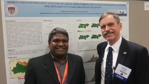
Credit: Nishan Kumar Biswas
What advice would you give your younger self?
I would use a quote from a movie called The Shawshank Redemption: “Remember, hope is a good thing, maybe the best of things, and no good thing ever dies.” So, keep trying harder and harder and keep your hope alive. Just focus on what you are passionate about, always monitor your growth, discover your limitations, and work on transforming the limitations into successes. One last thing: while it is normal for the focus of our scientific careers to be on professional development, including publishing in high impact factor journals, never forget to do your best for humanity. The world deserves your service in protecting humanity over everything else.
Credit: Nishan Kumar Biswas
Who inspires you?
A lot of people surrounding me have been inspirational during my career development. I would like to start by mentioning my parents. I am grateful to them because they are the ones who taught me how to be patient and not fearful of learning new things. They were able to make it clear to me that proper education is necessary to flourish in life. Among family members, I also want to recognize my father-in-law Prokash Chandra Sharma who played a pivotal role in convincing me to pursue my passions. There are a number of mentors and childhood friends who always went above and beyond for me. I can’t acknowledge individual names in here, but I will always remember them for their tremendous support. They showed me the path forward as I didn’t have many examples in front of me to follow. A few faculty members and friends from my undergraduate institute helped me to train academically and intellectually. When I started my job in Bangladesh, I worked with a few wonderful personalities full of passion and professionalism that inspired me in my current research. I am grateful to my PhD adviser, Dr. Faisal Hossain, for his exceptional mentorship and tremendous support during the toughest phase of my academic life. He always had faith in me and provided appropriate guidance whenever it was needed. Finally, I want to mention my wife Maumita Sharma and our two kids for their continuous sacrifices towards my career. They are the real source of light at every step of my life.

Credit: Niloy Acharjee
Biography
Home Town:
Jhenaidah, Bangladesh
Undergraduate Degree:
BS in Water Resources Engineering,
Bangladesh University of Engineering and Technology (BUET),
Dhaka, Bangladesh
Post-graduate Degrees:
Masters & Ph.D in Civil Engineering,
Department of Civil and Environmental Engineering,
University of Washington, Seattle, WA