Image Segmentation by Region Growing and Spectral Clustering with a Natural Convergence Criterion
Abstract -- The image segmentation approach described herein is a new hybrid of region growing and spectral clustering. This approach produces a specified number of hierarchical segmentations at different levels of detail, based upon jumps in a dissimilarity criterion. A recursive implementation of this segmentation approach on a cluster of 66 Pentium Pro PCs is described, and the effectiveness of this segmentation approach on Landsat Multispectral Scanner data is discussed.
INTRODUCTION
After a more detailed description of the segmentation approach, an implementation on a cluster of 66 Pentium Pro PCs is described, and the effectiveness of this segmentation approach on Landsat Multispectral Scanner (MSS) data is discussed.
HYBRID OF REGION GROWING AND SPECTRAL CLUSTERING
- Label each image pixel as a separate region and set the global criterion value, critval, equal to zero.
- Calculate the dissimilarity criterion value between each spatially adjacent region.
- Find the smallest dissimilarity criterion value, and merge all pairs of spatially adjacent regions with this criterion value.
- Calculate the dissimilarity criterion value between all pairs of non-spatially adjacent regions.
- Merge all pairs of non-spatially adjacent regions with dissimilarity criterion value less than or equal to the criterion value found in step 3.
- If the number of regions remaining is less than the preset value minregions, go to step 7. Otherwise go to step 2.
- Let prevcritval = critval. Reset critval to be the current global criterion value. If prevcritval = zero, go to step 2. Otherwise calculate cvratio = critval/prevcritval. If cvratio is greater than the preset threshold convfact, save the region label map from the previous iteration as a "raw" segmentation result. If the number of regions remaining is two or less, save the region label map from the current iteration as the coarsest instance of the final hierarchical segmentation result, and go to step 8. Otherwise go to step 2.
- Calculate the global criterion value over each region separately. For the region with maximum global criterion value, search backwards from the last "raw" segmentation result (from step 7) to an iteration where this region is split into two or more regions. Replace the labeling for this region with the labeling from the found iteration and store as the next more detailed level of the final hierarchical segmentation. Repeat this step until the preset number of levels in the final hierarchical segmentation is obtained.
Dissimilarity Criterion
Selection of an appropriate dissimilarity criterion is generally dependant on the application the resulting segmentations will be used for, and on the characteristics of the image data. Nevertheless, we have developed and studied a few general purpose similarity criteria for use with this algorithm, including criteria based on minimizing mean-square error and minimizing change in image entropy [4], and the "Normalized Vector Distance" from [5]. The "Euclidean Spectral Distance" (from [3]) is used as the dissimilarity criterion in the tests described later in this paper.For two regions i and j, characterized by the mean vectors Xi = (x1i, x2i,..., xci)T and Xj = (x1j, x2j,..., xcj)T, the Euclidean Spectral Distance (ESD) is defined as:
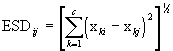 (1)
(1)where c is the number of spectral channels.
Global Criterion
The global criterion is used to identify significant changes in the segmentation results from one iteration to the next. This criterion is same as the dissimilarity criterion, except that it compares the original image data with the region mean image from the current segmentation. The value of this criterion is calculated at each image point and averaged over the entire image.The global criterion is also used to select which region is to be split in the final, backtracking stage of the algorithm. In this case the value of this criterion is calculated at each image point in the region under consideration, and is averaged over that region.
Parameter Settings
For the Landsat MSS data sets we have tested, we have found reasonable values for minregions to be in the range of 512 to 1024, or about one-half the total number of pixels in the image, whichever is less. Smaller values for minregions can produce image artifacts due to the divide-and-conquer, recursive implementation method (which is described later in this paper). Larger values result in longer execution times. For the same data sets, we have also found reasonable values for convfact to be in the range of 1.001 to 1.010.Discussion
Steps 2 and 3 make up the region growing portion of the algorithm and steps 4 and 5 constitute the spectral clustering portion. These region growing and spectral clustering steps are iterated until two or fewer regions remain. Results from these iterations are selectively saved in step 7 for the backtracking stage (step 8) based on the values of minregions and convfact. This set of "raw" segmentations saved in step 7 are analyzed in step 8 to produce the final set of hierarchical segmentations. In order to make viewing of the results more convenient, the region labels can be renumbered from largest region to the smallest. The convention employed is to label the "no data" areas as "0," and the largest region as "1."IMPLEMENTATION ON THE HIVE
The divide-and-and conquer, recursive implementation of the hybrid image segmentation algorithm is as follows:
- Specify the number of levels of recursion required (nblevels), and pad the input image, if necessary, so that the width and height of the image can be evenly divided by nblevels. Set level = nblevels. (A good value for nblevels results in the image section at level=1 consisting of roughly 500 to 2000 pixels.)
- Call recur_seg(level,image).
- If level > 1, divide the image data into quarters (in half in the width and height dimensions) and call recur_seg(level-1,image/4) for each image quarter (represented as image/4). Otherwise go to step 3.
- After all four calls to recur_seg() from step 1 complete processing, reassemble the image segmentation results.
- Execute the image segmentation algorithm outlined in the section HYBRID OF REGION GROWING AND SPECTRAL CLUSTERING with the following modification: If level < nblevels, terminate the algorithm when the number of regions reaches minregions/2, and do not check for critval or output any "raw" segmentation results.
SEGMENTATION RESULTS
The recursive version of the hybrid image segmentation has also been implemented on a conventional UNIX workstation. Table 1 compares wall clock run-times for segmentation using the HIVE as compared to a conventional workstation.
To demonstrate the effectiveness of the hybrid image segmentation algorithm in selecting out important region features from image data, it would be best to show several color pictures illustrating segmentations at several levels of detail. However, this is not possible in the restricted format of this proceedings. Such pictures will be provided during the oral presentation of this paper.
As a poor substitute for several color pictures, a verbal description of some segmentation results from a Landsat MSS scene (same as in Table 1) is given here. The coarsest segmentation is just two regions: one consists of nearly the whole image, while the other consists of two pixels of data that appears to be from a data anomaly. The next finer segmentation consists of seven regions, including some clouds, lakes and rivers, and some bright agricultural fields. At the finer segmentation levels, even more difficult features such as small roads and different lake depths are distinguished.
REFERENCES
[1] J. C. Tilton, "Image segmentation by iterative parallel region growing and splitting," Proc. 1989 International Geoscience and Remote Sensing Symposium, pp. 2235-2238, Vancouver, Canada, 1989.
[2] J.-M. Beaulieu and M. Goldberg, "Hierarchy in Picture Segmentation: A Stepwise Optimization Approach," IEEE Transactions on Pattern Analysis and Machine Intelligence, 11 (2), pp. 150-163, 1989.
[3] R. P. H. M. Schoenmakers, Integrated Methodology for Segmentation of Large Optical Satellite Image in Land Applications of Remote Sensing, Agriculture series, Catalogue number: CL-NA-16292-EN-C, Luxembourg: Office for Official Publications of the European Communities, 1995.
[4] J. C. Tilton, "Experiences using TAE-Plus command language for am image segmentation program interface," Proceedings of the TAE Ninth Users' Conference, New Carrollton, MD, pp. 297-312, 1991.
[5] A. Baraldi and F. Parmiggiani, "A neural network for unsupervised categorization of multivalued input patterns: an application to satellite image clustering," IEEE Transactions on Geoscience and Remote Sensing, vol. 33, no. 2, 305-316, 1995.
[6] D. J. Becker, T. Sterling, D. Savarese, J. E. Dorband, U. A. Ranawake, C. V. Parker, "Beowulf: A parallel workstation for scientific computation," Proceedings of the International Conference on Parallel Processing, 1995.
Table 1. Wall clock run times in minutes for the recursive
implementation of the hybrid image segmentation algorithm on the
HIVE and on a 167-MHz SunULTRA Model 170E Workstation. The image
processed is a 4-band Landsat MSS scene of north central Canada
obtained on Aug. 12, 1984. For this test minregions = 512
and convfact = 1.005. The refinement stage (step 8) is not
included in these timings.
|
|
|
|
|
|
|
|
|
|
|
|
|
|
|
|
|
|
|
|
|
|
|
|
|
|
|
|
|
|
|
|