Research Page
Climate Analysis
The goal of climate analysis is to better understand the Earth’s past and present climates, and to predict climate response to changes in natural and human-induced factors, such as the Sun, greenhouse gases (e.g., water vapor, carbon dioxide and methane), and aerosols (e.g., from dust storms, pollution, fires, sea spray or volcanic eruptions). Climate analysis studies are routinely carried out by combining data from diverse sources including historical climate records, current and past satellite instruments, field campaigns, and outputs from regional and global numerical models.
The energy budget of the Earth is controlled by the energy input from the Sun, namely the fraction absorbed by the Earth system, and thermal emission from the Earth itself. Laboratory scientists use space-based instruments to study the total and spectral incoming solar irradiance reaching the planet as well as the solar irradiance at the Earth’s surface using pyranometers and other ground-based instruments. Long-term, continuous measurements of both quantities play a crucial role in climate research. The end goal of these studies is to produce more accurate datasets for detecting changes in the energy balance across the globe. Lab scientists used these datasets to confirm that Earth’s radiative forcing has been increasing, largely due to emissions of greenhouse gases. This is one of the most direct pieces of observational evidence to date that humans are impacting the climate.
Lab scientists use direct observations, model analyses, and various satellite measurements to study the variability of the global hydrologic (water) cycle, including changes in the distribution of water vapor, precipitation, evaporation, and moisture transport as affected by naturally occurring climate fluctuations such as the El Nino Southern Oscillation (ENSO), the quasi-biennial oscillation (QBO), and others. Variations in rainfall and cloud characteristics, as well as the occurrence of extreme rainfall associated with sea surface temperature change, are being studied using Tropical Rainfall Measuring Mission (TRMM) and Global Precipitation Climatology Project (GPCP) rainfall data in conjunction with outputs from global numerical Earth-system models.
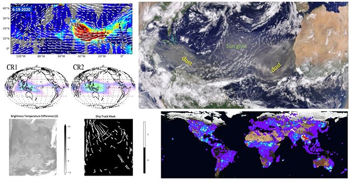
Aerosols, by virtue of their interaction with the Earth’s energy, water, and carbon cycles, are now recognized as a key element of the climate system. Aerosols can both cool the Earth’s surface by reflecting light back into space and heat the atmosphere by absorbing sunlight. Aerosols also interact with clouds and modify them in a way that can lead to further changes in the energy budget. When deposited on snowy surfaces, aerosols affect snow reflectivity and the melting processes. Deposition of aerosols into ocean and land provides essential nutrients for terrestrial and aquatic ecosystems. Lab scientists study the effect of aerosols on the atmospheric water cycle, particularly over highly populated monsoon regions where large concentrations of natural and anthropogenic (human-produced) aerosols can be found. Using satellite measurements of aerosol loading, snow, temperature, and rainfall, combined with model reanalysis data, Lab scientists investigate aerosol-induced changes in atmospheric circulation, snow cover, temperature, and rainfall. They also study the long-term variation of atmospheric aerosol loading and how it has affected the observed global diming and brightening in recent decades, intercontinental transport of aerosols and its effect on the ecosystems, the dust and cloud feedbacks amplifying the tropical North Atlantic multidecadal oscillation, the ocean surface temperature-driven African dust variability at decadal to millennial tiemscales, and potential long-term changes in surface air pollution and their effects.
With increasing volume of data from Earth observing satellites and models, new algorithms and methods are needed to make sense of the them in the context of climate analysis. Lab scientists are developing and applying machine learning (ML) techniques to obtain new insights from enormous data volumes. They use ML algorithms to examine how clouds organize into different clusters and morphologies; detect ship-tracks to study aerosol-cloud interactions; detect blowing snow in Antarctica. These advanced ML algorithms hold promise as tools that will unearth exciting new discoveries about the state of the Earth’s climate system.
Contact: Kyu-Myong Kim
The energy budget of the Earth is controlled by the energy input from the Sun, namely the fraction absorbed by the Earth system, and thermal emission from the Earth itself. Laboratory scientists use space-based instruments to study the total and spectral incoming solar irradiance reaching the planet as well as the solar irradiance at the Earth’s surface using pyranometers and other ground-based instruments. Long-term, continuous measurements of both quantities play a crucial role in climate research. The end goal of these studies is to produce more accurate datasets for detecting changes in the energy balance across the globe. Lab scientists used these datasets to confirm that Earth’s radiative forcing has been increasing, largely due to emissions of greenhouse gases. This is one of the most direct pieces of observational evidence to date that humans are impacting the climate.
Lab scientists use direct observations, model analyses, and various satellite measurements to study the variability of the global hydrologic (water) cycle, including changes in the distribution of water vapor, precipitation, evaporation, and moisture transport as affected by naturally occurring climate fluctuations such as the El Nino Southern Oscillation (ENSO), the quasi-biennial oscillation (QBO), and others. Variations in rainfall and cloud characteristics, as well as the occurrence of extreme rainfall associated with sea surface temperature change, are being studied using Tropical Rainfall Measuring Mission (TRMM) and Global Precipitation Climatology Project (GPCP) rainfall data in conjunction with outputs from global numerical Earth-system models.
Aerosols, by virtue of their interaction with the Earth’s energy, water, and carbon cycles, are now recognized as a key element of the climate system. Aerosols can both cool the Earth’s surface by reflecting light back into space and heat the atmosphere by absorbing sunlight. Aerosols also interact with clouds and modify them in a way that can lead to further changes in the energy budget. When deposited on snowy surfaces, aerosols affect snow reflectivity and the melting processes. Deposition of aerosols into ocean and land provides essential nutrients for terrestrial and aquatic ecosystems. Lab scientists study the effect of aerosols on the atmospheric water cycle, particularly over highly populated monsoon regions where large concentrations of natural and anthropogenic (human-produced) aerosols can be found. Using satellite measurements of aerosol loading, snow, temperature, and rainfall, combined with model reanalysis data, Lab scientists investigate aerosol-induced changes in atmospheric circulation, snow cover, temperature, and rainfall. They also study the long-term variation of atmospheric aerosol loading and how it has affected the observed global diming and brightening in recent decades, intercontinental transport of aerosols and its effect on the ecosystems, the dust and cloud feedbacks amplifying the tropical North Atlantic multidecadal oscillation, the ocean surface temperature-driven African dust variability at decadal to millennial tiemscales, and potential long-term changes in surface air pollution and their effects.
With increasing volume of data from Earth observing satellites and models, new algorithms and methods are needed to make sense of the them in the context of climate analysis. Lab scientists are developing and applying machine learning (ML) techniques to obtain new insights from enormous data volumes. They use ML algorithms to examine how clouds organize into different clusters and morphologies; detect ship-tracks to study aerosol-cloud interactions; detect blowing snow in Antarctica. These advanced ML algorithms hold promise as tools that will unearth exciting new discoveries about the state of the Earth’s climate system.
Contact: Kyu-Myong Kim