Research Page
Surface Properties
The reflectance of natural surfaces depends on viewing geometry, i.e., the position of the observer or measuring instrument relative to the Sun. Land surfaces usually appear darker in the forward scattering direction (i.e, with the Sun in front of the observer) and significantly brighter in the backscattering direction (i.e., with the Sun behind the observer). This dependence arises largely from the 3-D structure and roughness of the surface due to the interplay between shadowed and sunlit facets. For example, shadows are absent in the backscattering direction, which creates a reflectance “hot spot,” whereas they maximize in the forward scattering direction where they darken the surface. Solar photons may also be trapped bouncing between surface elements such as tree leaves before escaping. The number of such "internal" scattering events is modulated by the general brightness of the surface, creating additional angular dependence. Snow, the brightest type of surface at visible wavelengths, has maxima at both forward and backscattering angles, whereas water reflects light primarily in the forward scattering, or “glint,” direction. Wind forms waves and roughens water surfaces; stronger winds induce steeper waves, widening the glint "cone" and reducing its peak brightness.
Surface anisotropy is described by models of the bidirectional reflectance distribution function (BRDF) which is studied not just out of scientific curiosity, but for its many practical applications. BRDF defines the sun-angle dependence of surface albedo, one of the key parameters in climate and weather forecasting models that constrain the surface energy budget. It is also required in atmospheric and land remote sensing applications to obtain accurate assessments of atmospheric aerosol and the properties of thin clouds, surface type classification, snow characterization (e.g., sub-pixel snow fraction and grain size), detection of seasonal and rapid surface change, and many other applications.
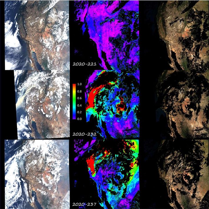
The development of accurate satellite data analysis methods for deriving spectral surface reflectance, BRDF and albedo is one of the important research directions of the Climate and Radiation Laboratory (CRL). This task starts with detection of clouds and cloud shadows in satellite imagery, proceeds with aerosol retrievals for the remaining cloud-free pixels, and concludes with the atmospheric correction which removes effects of light absorption and scattering by atmospheric gases and aerosols and computes spectral surface reflectance. The NASA’s Multi-Angle Implementation of Atmospheric Correction Algorithm (MAIAC), developed at CRL, is one of the most accurate and successful algorithms producing a suite of atmospheric aerosol and land surface reflectance properties. The complexity of the satellite data processing and skills of MAIAC in cloud detection, aerosol retrieval and atmospheric correction are illustrated in Figure 1 which shows three days of MODIS data over Western USA in August 2020 under extreme wildfire smoke conditions.
The Earth Observing System (EOS) MODIS and MISR instruments were the first to begin systematic surface reflectance and BRDF/albedo records since 2000. MISR obtains BRDF information by measuring reflected radiance at nine different view angles ranging from 70.5 in the forward direction to 70.5 in the backward direction along the satellite track. MODIS on the other hand accumulates multi-angle data up to 62 using several days of observations of the same region from different orbits. A similar strategy is pursued by the NOAA’s VIIRS instrument, a successor to MODIS, which started its measurement record in 2012. In contrast to the sun-synchronous MODIS and VIIRS on the polar orbit, the current geostationary satellites provide the complementary multi-angle information as the sun angle varies from dawn to dusk while keeping the view zenith and azimuth angles fixed for a given pixel. Currently, the MAIAC algorithm provides aerosol retrieval and atmospheric correction for MODIS and VIIRS, as well as for the geostationary ABI data from GOES-16 and 17, and AHI-8 HIMAWARI data. One more sensor with unique view geometry near the backscattering direction, also processed by MAIAC, is the Earth Polychromatic Imaging Camera (EPIC) on the NOAA’s Deep Space Climate Observatory (DSCOVR) platform stationed at the first Lagrange (L1) point approximately 1.5 million km from the Earth on the line connecting the Earth and the Sun.
The multi-sensor spectral surface reflectance, BRDF, and albedo are used by the land-user community for a wide range of basic science problems as well as va ariety of applications, such as mapping burn scars, land cover classification, characterization of vegetation properties and modeling gross primary production, a major component of the Earth system global carbon cycle.
Contact: Alexei Lyapustin
Surface anisotropy is described by models of the bidirectional reflectance distribution function (BRDF) which is studied not just out of scientific curiosity, but for its many practical applications. BRDF defines the sun-angle dependence of surface albedo, one of the key parameters in climate and weather forecasting models that constrain the surface energy budget. It is also required in atmospheric and land remote sensing applications to obtain accurate assessments of atmospheric aerosol and the properties of thin clouds, surface type classification, snow characterization (e.g., sub-pixel snow fraction and grain size), detection of seasonal and rapid surface change, and many other applications.
The development of accurate satellite data analysis methods for deriving spectral surface reflectance, BRDF and albedo is one of the important research directions of the Climate and Radiation Laboratory (CRL). This task starts with detection of clouds and cloud shadows in satellite imagery, proceeds with aerosol retrievals for the remaining cloud-free pixels, and concludes with the atmospheric correction which removes effects of light absorption and scattering by atmospheric gases and aerosols and computes spectral surface reflectance. The NASA’s Multi-Angle Implementation of Atmospheric Correction Algorithm (MAIAC), developed at CRL, is one of the most accurate and successful algorithms producing a suite of atmospheric aerosol and land surface reflectance properties. The complexity of the satellite data processing and skills of MAIAC in cloud detection, aerosol retrieval and atmospheric correction are illustrated in Figure 1 which shows three days of MODIS data over Western USA in August 2020 under extreme wildfire smoke conditions.
The Earth Observing System (EOS) MODIS and MISR instruments were the first to begin systematic surface reflectance and BRDF/albedo records since 2000. MISR obtains BRDF information by measuring reflected radiance at nine different view angles ranging from 70.5 in the forward direction to 70.5 in the backward direction along the satellite track. MODIS on the other hand accumulates multi-angle data up to 62 using several days of observations of the same region from different orbits. A similar strategy is pursued by the NOAA’s VIIRS instrument, a successor to MODIS, which started its measurement record in 2012. In contrast to the sun-synchronous MODIS and VIIRS on the polar orbit, the current geostationary satellites provide the complementary multi-angle information as the sun angle varies from dawn to dusk while keeping the view zenith and azimuth angles fixed for a given pixel. Currently, the MAIAC algorithm provides aerosol retrieval and atmospheric correction for MODIS and VIIRS, as well as for the geostationary ABI data from GOES-16 and 17, and AHI-8 HIMAWARI data. One more sensor with unique view geometry near the backscattering direction, also processed by MAIAC, is the Earth Polychromatic Imaging Camera (EPIC) on the NOAA’s Deep Space Climate Observatory (DSCOVR) platform stationed at the first Lagrange (L1) point approximately 1.5 million km from the Earth on the line connecting the Earth and the Sun.
The multi-sensor spectral surface reflectance, BRDF, and albedo are used by the land-user community for a wide range of basic science problems as well as va ariety of applications, such as mapping burn scars, land cover classification, characterization of vegetation properties and modeling gross primary production, a major component of the Earth system global carbon cycle.
Contact: Alexei Lyapustin