Research Page
Water Cycle and Precipitation
Earth is the only inner planet where all three phases of water (liquid, ice, and vapor) coexist, and 70% of its surface is covered by oceans. The various transport mechanisms of water and its perpetual phase changes are essential elements of the planetary water cycle (also known as the hydrological cycle). Precipitation is a major component of the planet’s water cycle, and is the source of most of its fresh water. It occurs when water vapor levels in the atmosphere reach saturation upon which water vapor condenses or deposits on small particles called condensation/ice nuclei to form clouds consisting of suspended liquid or ice particles or a mixture of both. Under appropriate conditions larger liquid and ice particles form inside the clouds, fall through the atmosphere because of gravity, and often survive evaporation to reach the surface as precipitation. Precipitation is associated with a vast range of weather events: tropical cyclones, thunderstorms, frontal systems, drizzle, snowfall, etc.
The ultimate driving force of precipitation and the water cycle is the solar energy from the Sun. Earth maintains a delicate balance of radiative energy by reflecting approximately one third of the incoming solar radiation, and emitting the remaining two-thirds that are absorbed as infrared radiation back to space. At the Earth’s surface and within the atmosphere, the energy balance is more complex than for the planet as a whole. In fact, neither the surface nor atmosphere can achieve radiative energy balance by themselves without the critical involvement of water. The surface absorbs more solar radiation than is lost by net emission of infrared radiation, with the excess energy transferred to the atmosphere mostly in the form of latent heat – the energy required to evaporate surface water and then released to the atmosphere upon cloud formation and precipitation. The water in the atmosphere, whether in vapor, liquid or ice form, further affects atmospheric heating or cooling via radiative interactions. Thus, the cycling of water among its different phases, and its transport across the globe (i.e., between the surface and atmosphere, the ocean and land, and from the tropics to the poles and back), are all intricately connected and responsible for the water cycle of the Earth.
The physical processes governing the water and energy cycles are extremely complicated, involving scales ranging from the planetary to the microscopic. Any alterations in atmospheric gaseous composition (water vapor, carbon dioxide, ozone, etc.), particulates (desert dust, smoke, urban smog, etc), or clouds (coverage and brightness) can disturb the radiative heat balance and produce chain reactions to the hydrological cycle. It is very important for the climate community to not only closely monitor the regional and global water budget, but to also understand changes in the frequency and strength of individual weather events. This is especially true of extreme weather events, which have great societal and economic impacts. Whether we will have more frequent or more intense tropical storms, mega-snow events, or prolonged droughts inducive of wildfires in the near or far future is a key focus area of climate research.
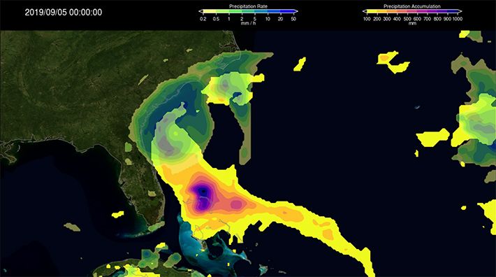
Scientists in the Climate and Radiation Lab make synergistic use of satellite and ground-based observations of precipitation and clouds, as well as numerical simulations to conduct research on various components of the water cycle, their variabilities, long-term trends, and relationships to other aspects of the climate system. In collaboration with the Mesoscale Processes Lab, CRL investigators contribute to the development, evaluation, and application of precipitation observations, with a focus on how they interact to clouds, radiation, convection, and extreme events. For example, recent research explored how the precipitation characteristics of different cloud regimes vary, while also examined how the accuracy of satellite precipitation depends on the cloud regimes. This intimate connection between clouds and precipitation is also central to ongoing efforts at estimating the surface precipitation using infrared observations of clouds, which is a key component of global precipitation products such as the Integrated Multi-satellitE Retrievals for GPM (IMERG), the most used product from the Global Precipitation Measurement (GPM) mission. Not only have scientists in the Climate and Radiation Lab contributed to the development of IMERG, but they have also used IMERG to identify and characterize extreme precipitation that can cause floods and landslides. Research focusing on the relationship of these extreme events with atmospheric convection and radiation is crucial in advancing our understanding of such dangerous and costly hazards, while simultaneous efforts at developing a monitoring system will enable society to mitigate the harm that may arise.
Contact: Yaping Zhou
The ultimate driving force of precipitation and the water cycle is the solar energy from the Sun. Earth maintains a delicate balance of radiative energy by reflecting approximately one third of the incoming solar radiation, and emitting the remaining two-thirds that are absorbed as infrared radiation back to space. At the Earth’s surface and within the atmosphere, the energy balance is more complex than for the planet as a whole. In fact, neither the surface nor atmosphere can achieve radiative energy balance by themselves without the critical involvement of water. The surface absorbs more solar radiation than is lost by net emission of infrared radiation, with the excess energy transferred to the atmosphere mostly in the form of latent heat – the energy required to evaporate surface water and then released to the atmosphere upon cloud formation and precipitation. The water in the atmosphere, whether in vapor, liquid or ice form, further affects atmospheric heating or cooling via radiative interactions. Thus, the cycling of water among its different phases, and its transport across the globe (i.e., between the surface and atmosphere, the ocean and land, and from the tropics to the poles and back), are all intricately connected and responsible for the water cycle of the Earth.
The physical processes governing the water and energy cycles are extremely complicated, involving scales ranging from the planetary to the microscopic. Any alterations in atmospheric gaseous composition (water vapor, carbon dioxide, ozone, etc.), particulates (desert dust, smoke, urban smog, etc), or clouds (coverage and brightness) can disturb the radiative heat balance and produce chain reactions to the hydrological cycle. It is very important for the climate community to not only closely monitor the regional and global water budget, but to also understand changes in the frequency and strength of individual weather events. This is especially true of extreme weather events, which have great societal and economic impacts. Whether we will have more frequent or more intense tropical storms, mega-snow events, or prolonged droughts inducive of wildfires in the near or far future is a key focus area of climate research.
Scientists in the Climate and Radiation Lab make synergistic use of satellite and ground-based observations of precipitation and clouds, as well as numerical simulations to conduct research on various components of the water cycle, their variabilities, long-term trends, and relationships to other aspects of the climate system. In collaboration with the Mesoscale Processes Lab, CRL investigators contribute to the development, evaluation, and application of precipitation observations, with a focus on how they interact to clouds, radiation, convection, and extreme events. For example, recent research explored how the precipitation characteristics of different cloud regimes vary, while also examined how the accuracy of satellite precipitation depends on the cloud regimes. This intimate connection between clouds and precipitation is also central to ongoing efforts at estimating the surface precipitation using infrared observations of clouds, which is a key component of global precipitation products such as the Integrated Multi-satellitE Retrievals for GPM (IMERG), the most used product from the Global Precipitation Measurement (GPM) mission. Not only have scientists in the Climate and Radiation Lab contributed to the development of IMERG, but they have also used IMERG to identify and characterize extreme precipitation that can cause floods and landslides. Research focusing on the relationship of these extreme events with atmospheric convection and radiation is crucial in advancing our understanding of such dangerous and costly hazards, while simultaneous efforts at developing a monitoring system will enable society to mitigate the harm that may arise.
Contact: Yaping Zhou