Research Page
Aerosol Remote Sensing and Modeling
The Climate and Radiation Laboratory (CRL) has a very active group studying the climate, air quality, and other impacts of airborne particles (“aerosols”). Aerosol particles reflect sunlight, which tends to cool surfaces locally. Some also absorb sunlight, warming and stabilizing the ambient atmosphere while still cooling the surface below, sometimes suppressing cloud formation, and even affecting large-scale atmospheric circulation. In addition, aerosols are critical participants in the formation of cloud droplets and ice crystals, functioning as the collectors of water vapor molecules during the initial stages of cloud development. Particle abundance and properties affect the brightness, thickness, and possibly lifetimes of clouds and ultimately, precipitation and the terrestrial water cycle. And in significant near-surface concentrations they are pollutants, reducing visibility and raising both short- and long-term health risks for those exposed.
Airborne particles originate from a great variety of sources, such as wildfires, volcanoes, exposed soils and desert sands, breaking waves, natural biological activity, agricultural burning, cement production, and wood, dung, and fossil fuel combustion. The particles having the largest direct environmental impact are sub-visible, ranging in size from about a hundredth to a few tenths the diameter of a human hair (about 0.1 to 10 micrometers). They typically remain in the atmosphere from several days to a week or more, and some travel great distances before returning to the Earth’s surface via gravitational settling or washout by precipitation. As such, they can affect regions thousands of kilometers from their sources: dust from the Sahara Desert, transported across the Atlantic Ocean, supplies micro- and macro-nutrients to the underlying ocean surface waters, occasionally limits visibility in Florida and the Caribbean, and possibly fertilizes the Amazon basin. Pollution and dust from East Asia sometimes reach North America, and smoke from summertime fires in Siberia, northern Canada, and Alaska darken snow surfaces in the Arctic.
Developing an understanding of the mechanisms that produce, transport, chemically alter and eventually remove particles from the atmosphere, and actually quantifying aerosol impacts, requires carefully characterized global data sets. These datasets in turn, must be subjected to intense numerical analysis, and integrated into chemical transport and climate models. The constrained models can then be used to simulate the effects aerosols have on the planet’s energy balance, atmospheric circulation, and water cycle, and to make predictions about impacts, based on scenarios representing different choices civilization might make in the future.
The global scope of aerosol environmental influences makes satellite remote sensing a key tool for the study of these particles. The presence of high concentrations of desert dust, wildfire smoke, volcanic ash, and/or urban pollution leads to dramatic imagery (e.g., http://earthobservatory.nasa.gov/Images/). Even for lower concentrations, satellite remote sensing can quantify the total aerosol loading, while also providing meaningful constraints on relative aerosol size, light absorption properties, and the type of aerosol observed. However, in order for satellite aerosol retrievals to provide a useful constraint on climate and air quality they must be validated with more detailed measurements obtained by aircraft and ground-based instruments.
The majority of the work performed by CRL’s aerosol scientists aims to improve our understanding of aerosols using satellite measurements. Through collaborations within NASA, with other U.S. agencies, and with international colleagues, CRL scientists apply these data to constraining climate and air quality modeling efforts. Our group includes the core aerosol science team for the NASA Earth Observing System’s MODerate resolution Imaging Spectroradiometer (MISR).The MODIS Dark Target, Deep Blue, and MAIAC aerosol algorithms are developed and maintained here, along with the MISR Research Aerosol Retrieval algorithm. We contribute to the Total Ozone Mapping Spectrometer (TOMS), the Sea-viewing Wide Field-of-view Sensor (SeaWiFS), and the Suomi National Polar-orbiting Partnership’s Visible Infrared Imaging Radiometer Suite (SNPP-VIIRS) aerosol retrieval algorithms. Recently, our team has been porting existing and developing new algorithms to take advantage of sensors in Geostationary orbit (such as GOES-R) and other instruments that reside even further from Earth (e.g., EPIC). Finally, we are heavily involved with the development of new satellite capabilities, including algorithms and science definitions for the Plankton, Aerosol, Cloud, ocean Ecosystem (PACE), the Multi-Angle Imager for Aerosols (MAIA), and the Earth System Observatory-Atmosphere Observing System (EOS-AOS) study.
For each algorithm and satellite product, we perform validation studies using ground-based remote-sensing aerosol measurements, such as those provided by the global Aerosol Robotic Network (AERONET) of Sun- and sky-scanning photometers and the Micro-Pulse Lidar Network (MPLNet). And through the Goddard Interactive Online Visualization ANd aNalysis Infrastructure (GIOVANNI), we have participated in the development of web-based tools to collocate multiple satellite and AERONET products and to analyze them statistically.
To retrieve aerosol properties in greater detail, and to better understand the processes by which these particles interact with the environment, we participate in aircraft field measurement campaigns and analyze the resulting data. During field operations, we contribute satellite-aircraft coordination and flight-planning expertise aimed at maximizing science return, some near-real-time satellite aerosol products, and on-the-spot analysis. In addition, we have developed and maintain a state-of-the-art, ground-based mobile facility for measuring the physical and chemical properties of aerosol and clouds, along with the ambient radiation fields (SMART-COMMIT-ACHIEVE). Recently, we have also been performing high resolution retrievals using airborne sensors including the enhanced MODIS Airborne Simulator (eMAS).
We are the global leader for aerosol retrieval algorithms and satellite-based products, that result in detailed studies of wildfire smoke, dust storms, volcanic ash plumes, and other aerosol pollution events. In addition, we lead and contribute to fundamental radiative transfer theory and computer codes that are used in satellite aerosol retrieval algorithms, studies quantifying short and long term health effects from exposure to particulate matter, as well as large-scale aerosol transport, global energy balance assessments, and climate change studies. Research outcomes of the group have contributed significantly to national and international assessments conducted by the Intergovernmental Panel on Climate Change (IPCC), the U.S. Climate Change Science Program (CCSP), and the United Nations’ Task Force on Hemispheric Transport of Air Pollution (HTAP), among others. As part of our participation in the wider aerosol and climate change communities, we host the AeroCenter seminars, which are webcast regularly so that interested parties can attend remotely and co-chair AeroSat, the International Satellite Aerosol Science Network.
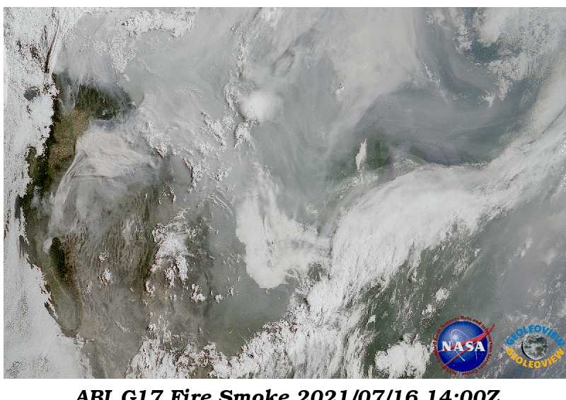
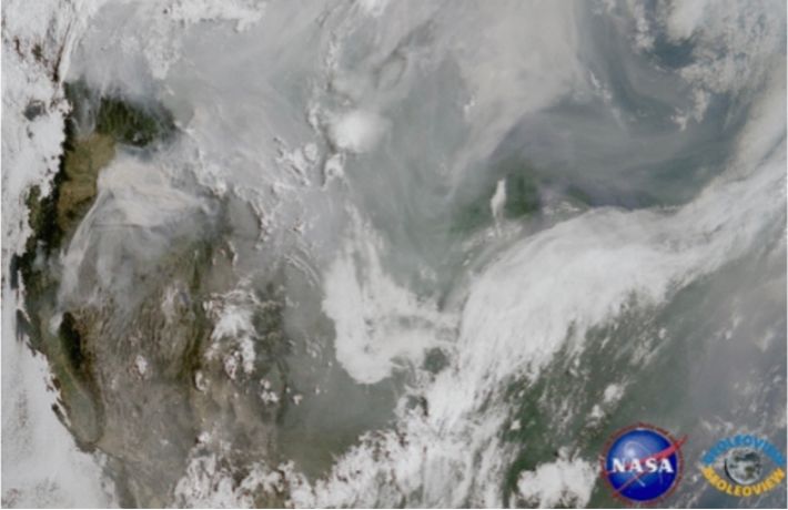
The summer of 2021 was a severe fire season in the Western U.S. and Canada, and the smoke from these fires was transported across nearly the entirety of the continental U.S. High concentrations of surface Particulate Matter (PM) concentrations and poor air quality were observed in cities such as New York City.
The animation above stitches together 5 days of daylight imagery (at 10 minute intervals) from the Advanced Baseline Imager (ABI) on the GOES-West (GOES-17) satellite in Geostationary orbit. These “true-color” RGB images are composites of reflectance in the Red = 0.67 mm, Green = 0.55 mm and Blue = 0.47 mm wavelength bands. However, the ABI has no actual Green band channel, so Green reflectance is estimated from other wavelengths.
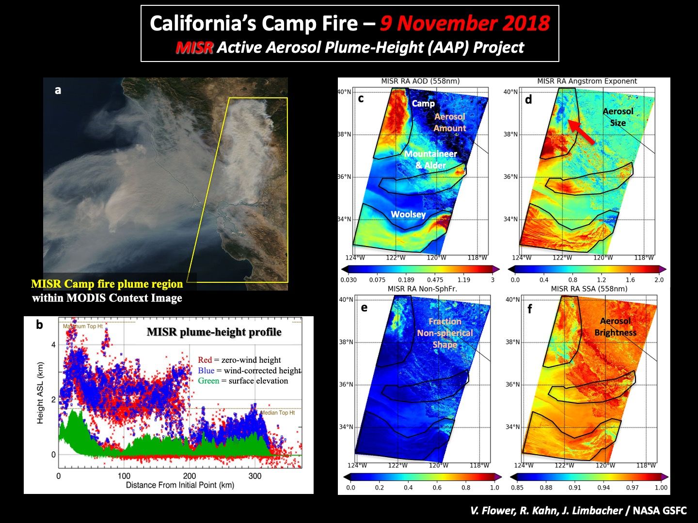
The Camp Fire in northern California, the deadliest in the state’s history, (a) was viewed from space by the NASA Earth Observing System’s multi-angle MISR and broad-swath MODIS imagers on Nov. 9, 2018. (b) The wildfire lofted smoke 2-3 km above the terrain, as shown in this downwind profile of plume heights derived from MISR. With nine cameras viewing the same location at multiple angles over about 7 minutes, the elevation of contrast elements in the plume were retrieved geometrically from the stereo images (red dots), and the heights were also corrected for plume motion (blue dots). Note that the plume descends abruptly to near-surface as it approaches the coast and the cooler air above the ocean. (c) Smoke amount for the Camp fire plume is shown in the northwest part of the MISR swath. Smoke plumes from several other fires also appear in the swath. In addition to smoke amount, particle properties were derived from the MISR data with a research algorithm: (d) particle size, (e) fraction of non-spherical particles (usually soil or mineral dust), and (f) particle brightness. The red arrow in panel (d) points to the location of the town of Paradise, California within the Camp fire plume. Note that compared to particles from the surrounding burning vegetation, smoke particles from the burning town were larger, brighter, and more non-spherical.
Contact: Ralph Kahn
Airborne particles originate from a great variety of sources, such as wildfires, volcanoes, exposed soils and desert sands, breaking waves, natural biological activity, agricultural burning, cement production, and wood, dung, and fossil fuel combustion. The particles having the largest direct environmental impact are sub-visible, ranging in size from about a hundredth to a few tenths the diameter of a human hair (about 0.1 to 10 micrometers). They typically remain in the atmosphere from several days to a week or more, and some travel great distances before returning to the Earth’s surface via gravitational settling or washout by precipitation. As such, they can affect regions thousands of kilometers from their sources: dust from the Sahara Desert, transported across the Atlantic Ocean, supplies micro- and macro-nutrients to the underlying ocean surface waters, occasionally limits visibility in Florida and the Caribbean, and possibly fertilizes the Amazon basin. Pollution and dust from East Asia sometimes reach North America, and smoke from summertime fires in Siberia, northern Canada, and Alaska darken snow surfaces in the Arctic.
Developing an understanding of the mechanisms that produce, transport, chemically alter and eventually remove particles from the atmosphere, and actually quantifying aerosol impacts, requires carefully characterized global data sets. These datasets in turn, must be subjected to intense numerical analysis, and integrated into chemical transport and climate models. The constrained models can then be used to simulate the effects aerosols have on the planet’s energy balance, atmospheric circulation, and water cycle, and to make predictions about impacts, based on scenarios representing different choices civilization might make in the future.
The global scope of aerosol environmental influences makes satellite remote sensing a key tool for the study of these particles. The presence of high concentrations of desert dust, wildfire smoke, volcanic ash, and/or urban pollution leads to dramatic imagery (e.g., http://earthobservatory.nasa.gov/Images/). Even for lower concentrations, satellite remote sensing can quantify the total aerosol loading, while also providing meaningful constraints on relative aerosol size, light absorption properties, and the type of aerosol observed. However, in order for satellite aerosol retrievals to provide a useful constraint on climate and air quality they must be validated with more detailed measurements obtained by aircraft and ground-based instruments.
The majority of the work performed by CRL’s aerosol scientists aims to improve our understanding of aerosols using satellite measurements. Through collaborations within NASA, with other U.S. agencies, and with international colleagues, CRL scientists apply these data to constraining climate and air quality modeling efforts. Our group includes the core aerosol science team for the NASA Earth Observing System’s MODerate resolution Imaging Spectroradiometer (MISR).The MODIS Dark Target, Deep Blue, and MAIAC aerosol algorithms are developed and maintained here, along with the MISR Research Aerosol Retrieval algorithm. We contribute to the Total Ozone Mapping Spectrometer (TOMS), the Sea-viewing Wide Field-of-view Sensor (SeaWiFS), and the Suomi National Polar-orbiting Partnership’s Visible Infrared Imaging Radiometer Suite (SNPP-VIIRS) aerosol retrieval algorithms. Recently, our team has been porting existing and developing new algorithms to take advantage of sensors in Geostationary orbit (such as GOES-R) and other instruments that reside even further from Earth (e.g., EPIC). Finally, we are heavily involved with the development of new satellite capabilities, including algorithms and science definitions for the Plankton, Aerosol, Cloud, ocean Ecosystem (PACE), the Multi-Angle Imager for Aerosols (MAIA), and the Earth System Observatory-Atmosphere Observing System (EOS-AOS) study.
For each algorithm and satellite product, we perform validation studies using ground-based remote-sensing aerosol measurements, such as those provided by the global Aerosol Robotic Network (AERONET) of Sun- and sky-scanning photometers and the Micro-Pulse Lidar Network (MPLNet). And through the Goddard Interactive Online Visualization ANd aNalysis Infrastructure (GIOVANNI), we have participated in the development of web-based tools to collocate multiple satellite and AERONET products and to analyze them statistically.
To retrieve aerosol properties in greater detail, and to better understand the processes by which these particles interact with the environment, we participate in aircraft field measurement campaigns and analyze the resulting data. During field operations, we contribute satellite-aircraft coordination and flight-planning expertise aimed at maximizing science return, some near-real-time satellite aerosol products, and on-the-spot analysis. In addition, we have developed and maintain a state-of-the-art, ground-based mobile facility for measuring the physical and chemical properties of aerosol and clouds, along with the ambient radiation fields (SMART-COMMIT-ACHIEVE). Recently, we have also been performing high resolution retrievals using airborne sensors including the enhanced MODIS Airborne Simulator (eMAS).
We are the global leader for aerosol retrieval algorithms and satellite-based products, that result in detailed studies of wildfire smoke, dust storms, volcanic ash plumes, and other aerosol pollution events. In addition, we lead and contribute to fundamental radiative transfer theory and computer codes that are used in satellite aerosol retrieval algorithms, studies quantifying short and long term health effects from exposure to particulate matter, as well as large-scale aerosol transport, global energy balance assessments, and climate change studies. Research outcomes of the group have contributed significantly to national and international assessments conducted by the Intergovernmental Panel on Climate Change (IPCC), the U.S. Climate Change Science Program (CCSP), and the United Nations’ Task Force on Hemispheric Transport of Air Pollution (HTAP), among others. As part of our participation in the wider aerosol and climate change communities, we host the AeroCenter seminars, which are webcast regularly so that interested parties can attend remotely and co-chair AeroSat, the International Satellite Aerosol Science Network.
The summer of 2021 was a severe fire season in the Western U.S. and Canada, and the smoke from these fires was transported across nearly the entirety of the continental U.S. High concentrations of surface Particulate Matter (PM) concentrations and poor air quality were observed in cities such as New York City.
The animation above stitches together 5 days of daylight imagery (at 10 minute intervals) from the Advanced Baseline Imager (ABI) on the GOES-West (GOES-17) satellite in Geostationary orbit. These “true-color” RGB images are composites of reflectance in the Red = 0.67 mm, Green = 0.55 mm and Blue = 0.47 mm wavelength bands. However, the ABI has no actual Green band channel, so Green reflectance is estimated from other wavelengths.
The Camp Fire in northern California, the deadliest in the state’s history, (a) was viewed from space by the NASA Earth Observing System’s multi-angle MISR and broad-swath MODIS imagers on Nov. 9, 2018. (b) The wildfire lofted smoke 2-3 km above the terrain, as shown in this downwind profile of plume heights derived from MISR. With nine cameras viewing the same location at multiple angles over about 7 minutes, the elevation of contrast elements in the plume were retrieved geometrically from the stereo images (red dots), and the heights were also corrected for plume motion (blue dots). Note that the plume descends abruptly to near-surface as it approaches the coast and the cooler air above the ocean. (c) Smoke amount for the Camp fire plume is shown in the northwest part of the MISR swath. Smoke plumes from several other fires also appear in the swath. In addition to smoke amount, particle properties were derived from the MISR data with a research algorithm: (d) particle size, (e) fraction of non-spherical particles (usually soil or mineral dust), and (f) particle brightness. The red arrow in panel (d) points to the location of the town of Paradise, California within the Camp fire plume. Note that compared to particles from the surrounding burning vegetation, smoke particles from the burning town were larger, brighter, and more non-spherical.
Contact: Ralph Kahn